Water Scarcity: Elephant Butte Water Reservoir | Sierra County
Kathleen Kambic charts the complicated regime controlling and managing water in the Lower Rio Grande valley.
The Rio Grande is the fourth-longest river in the US, but it carries only a fraction of the water other American rivers carry. It drains 11 percent of the continental US.
Elephant Butte is the principal storage facility and delivery point for water going to Texas according to the Rio Grande Compact. Water is first measured at Otowi Gauge, north of Espanola, to determine how much can be sent to Texas. Water is again measured at the dam to ensure the correct volumes have made it downstream.
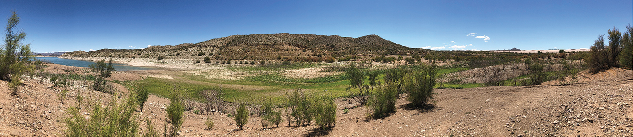
View of Elephant Butte, with water to the left and the dam to the right. Wetlands fill the gap.
Elephant Butte has three 8,100 kilowatt generators and delivers power along a 490-mile transmission system, with half of the power going to New Mexico and the other half to Texas. Hydroelectric power requires constantly moving water, which is problematic for irrigation conservation. Caballo Reservoir was built downstream in 1938 to catch the used hydropower water so it can be released on schedule for the irrigation season to Mexico, in accordance with the treaty of 1905. This year has already seen marked drops in water levels in the Rio Grande, but Caballo Reservoir is full.
The beach at Elephant Butte Reservoir.
Elephant Butte is a significant area for outdoor recreation in the state of New Mexico. Boating, swimming, fishing, and camping are very popular, with up to 125,000 people visiting just over the July 4th weekend. The towns of Truth or Consequences (which is replete with hot springs) and Elephant Butte depend on the influx of tourists to maintain local businesses. Tourism brings 1.5 million people to Sierra County each year. The county is focused on maintaining facilities such as reservoir access, boat marinas, and boat storage for the future. The drop in water levels has required that the marinas be lowered multiple times.
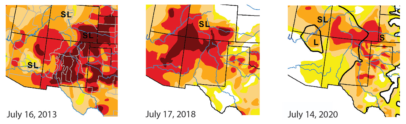
The United States Drought Monitor shows a significant difference between July 2013, 2018, and 2020. 2012 and 2013 were the worst drought years in over one hundred years for New Mexico, with significant wildfire damage and drought throughout the state. 2018 was also particularly bad, with reservoir capacity dropping to 3 percent. Snowpack predictions show a coming La Niña system in 2021 that will further limit rain and snowfall amounts in the state as the jet stream pushes storms northward. If this trend continues, more water will be needed to irrigate, crop production will likely drop, and inflows into the reservoir will further diminish. The little riparian habitat that exists may disappear. Although wildfire along the Rio Grande corridor is uncommon, smoke, erosion, sedimentation, and impaired wildlife can all occur in the area due to fires along the entire river corridor.
US Drought Monitor maps for the Southwest showing extreme and exceptional drought (red and dark red) during two of the worst drought years in recent memory and this year. Black lines show dominant impact areas. S = short-term drought, L = long-term drought.
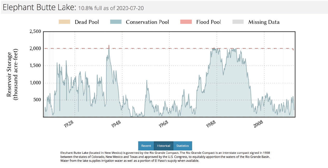
Construction of Elephant Butte Reservoir was completed in 1916. The reservoir is four miles wide and 40 miles long and can hold over two million acre-feet of water. The historical data in the Water Data for Texas graph shows that lake levels have fluctuated dramatically over the past hundred-plus years. The lowest storage level occurred in 1954, when only 1 percent of the reservoir filled. Over the past 20 years, the reservoir has never refilled, due to extenuated drought and climate shifts. Significant wetlands have grown at both ends of the reservoir due to the collapse of water volumes.
Historical Data for Elephant Butte Reservoir from Water Data for Texas website.
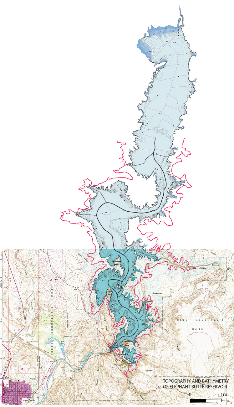
On the map showing the topography and bathymetry of the reservoir, the pink line shows the approximate flood level of the reservoir (4415’). The black line shows deadpool, where the reservoir can no longer function and is once again a slow-moving river with wetlands (4231’). Water has only topped the spillway a few times, in 1941 and in the 1980s and 90s. Water is moved out through pumps connected to the hydropower system, though it is unclear how water could be moved downriver at this point.
Map showing topography and bathymetry at the reservoir.
This article is part of “Water Scarcity: Elephant Butte Reservoir,” written solely by Kathleen Kambic, assistant professor at the University of New Mexico. All images are her work alone, unless noted otherwise in the text.
Click here to view this feature’s references.
The views expressed here are those of the authors only and do not reflect the position of The Architectural League of New York.