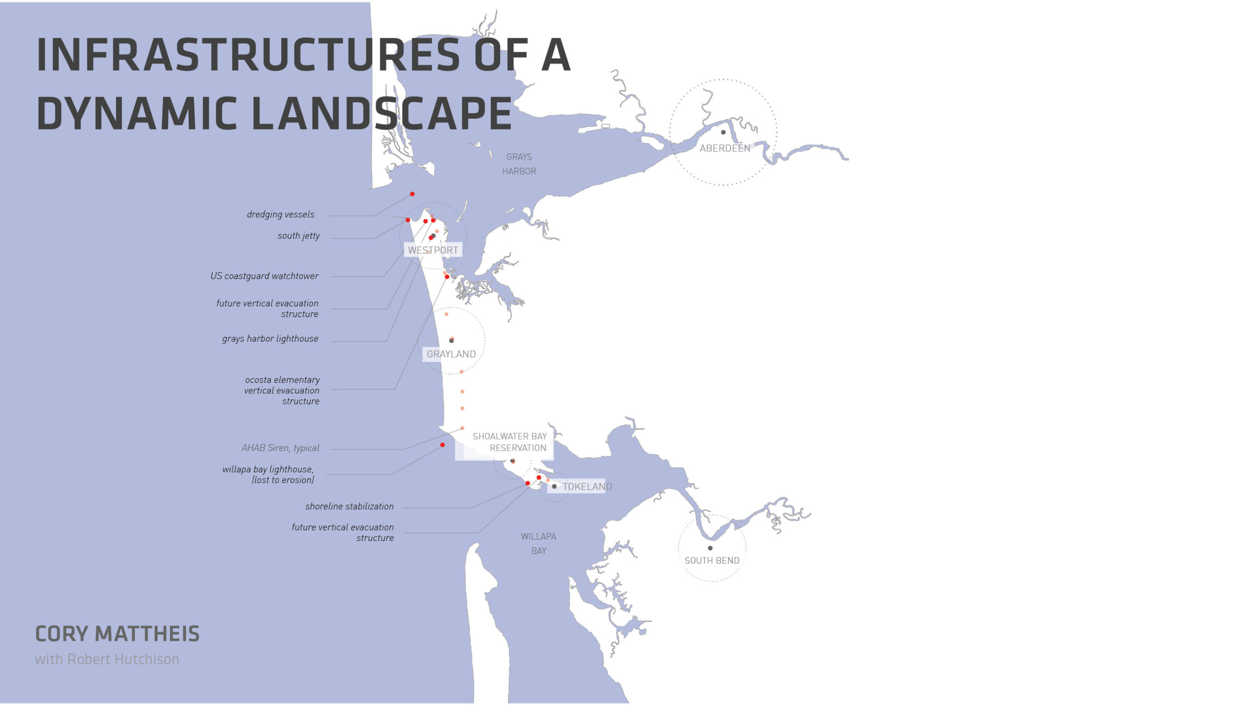
The South Beach communities, stretching from Westport at the northern tip of Point Chehalis to Tokeland at the mouth of Willapa Bay, are served by various forms of infrastructure commonly found throughout other rural American communities, including roadways; bridges; water storage and water treatment centers and associated conveyance systems; telecommunication and electrical grids; waste management; and ports/marinas. Yet with its immediate and direct relationship to the Pacific Ocean, precariously located on one of the most dynamic coastlines of the west coast of North America, the South Beach community is susceptible to ongoing beach erosion and sedimentation, storm surge and sea level rise, and the possibility of a future tsunami. Over time, these perilous conditions have resulted in the development of a series of regional infrastructure typologies unique to the place, which together tell a story about the relationship of land and ocean and the resilient people who live here.
As a means to describe the relationship between infrastructure and the landscape, as well as to articulate the specific technical qualities of each infrastructure typology, we have documented the unique infrastructures of the South Beach community through photography and architectural graphics. As a means to further clarify the roles of the infrastructures to the community, we have organized them into three categories. Monitoring Infrastructures are systems used to monitor and observe conditions, including Coast Guard watchtowers, tsunami siren towers, and lighthouses. Engaging Infrastructures are systems that involve the direct engagement of humans with natural forces and the landscape: jetties, dredging, and shoreline stabilization. Finally, Sheltering Infrastructures are systems developed to protect and support the community, specifically vertical evacuation structures designed to provide safe haven for residents in the case of a tsunami event.
Monitoring Infrastructure
US Coast Guard Watchtower
Situated on the south side of the entrance to Grays Harbor from the Pacific Ocean, the city of Westport has been home to a US Coast Guard station since 1915 and is proud to have been designated as an official Coast Guard City. “The Coast Guard manages six major operational mission programs: maritime law enforcement, maritime response, maritime prevention, maritime transportation system management, maritime security operations, and defense operations.”1“The Coast Guard’s Work Near You (Districts and News)” United States Coast Guard, U.S. Department of Homeland Security.
“You can get yourself killed on a sunny day out there, don’t let the sunshine and blue skies fool you.”
– John Shaw, executive director of the Westport South Beach Historical Society
Coast Guard watchtowers allow crewmembers to keep an eye on changing sea conditions (“reading the bar”) and vessel traffic. During inclement weather, flags are flown on the tower to communicate storm conditions to vessels.
Left: US Coast Guard Station (USCG) at Halfmoon Bay, 2020. Credit: Eirik Johnson. Right: Historic photograph of Halfmoon Bay and USCG tower in full gale winds. Credit: Del Mulkey, courtesy of the Westport South Beach Historical Society
The height of the watchtower is driven by the lines of sight required between tower and vessel, as well as by visibility conditions defined by local weather conditions. To achieve the desired height, and to counter the lateral forces of extreme winds with a very small footprint, towers are typically constructed using lightweight, prefabricated steel members assembled as a three-dimensional truss cantilevered from the ground. Regularly stationed by a single crewmember who is tasked with conducting and communicating visual observations of the bar, watchtowers serve as analog instruments that stand sentinel over the coast.
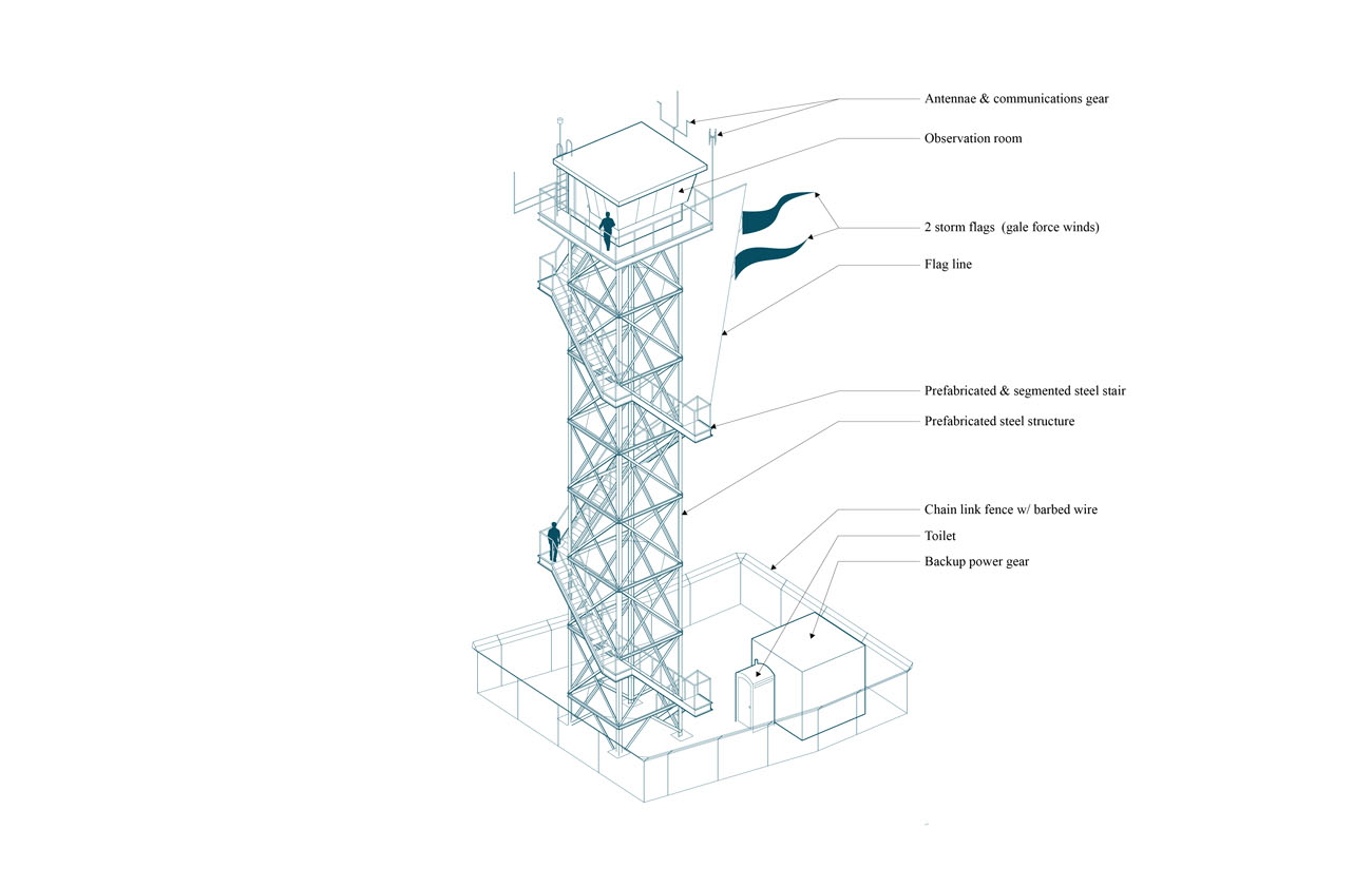
Watchtower diagram. Credit: Cory Mattheis
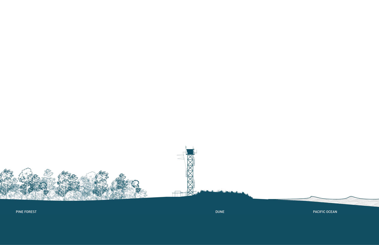
Section through the landscape: The verticality of the watchtower accentuates the overwhelming horizontality of the landscape and ocean. Credit: Cory Mattheis
DART Offshore Buoy Station
The National Oceanic and Atmospheric Administration (NOAA) Tsunami Program operates in partnership with federal, state, and international organizations to minimize the impacts of tsunamis. The program includes observation systems, forecast models, and messaging in the event of a tsunami. To provide early detection of tsunamis, NOAA has deployed 39 DART (Deep Ocean Assessment and Reporting of Tsunamis) offshore buoy stations in regions with a history of tsunamis.
Each DART station consists of an anchored seafloor bottom pressure recorder (BPR), typically located 1,000 to 6,000 meters below sea level, that communicates real-time pressure changes to a companion moored surface buoy.2NOAA Tsunami Program, National Oceanic and Atmospheric Administration. The buoy then transmits data via satellite to one of two national Tsunami Warning Centers, which in turn send warning signals to local networks of AHAB (All Hazard Alert Broadcast) sirens.
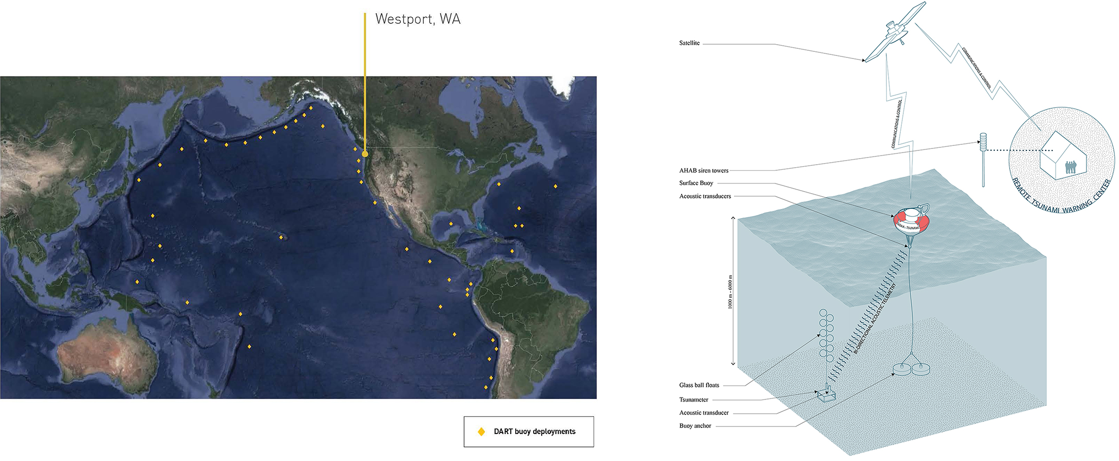
Left: Map courtesy of Cory Mattheis and Robert Hutchison. Right: Schematic diagram of DART (Deep Ocean Assessment and Reporting of Tsunamis) components. Credit: Cory Mattheis
AHAB Siren System
The AHAB siren system is a state-maintained distributed series of siren towers designed to warn communities of a potential tsunami event. The South Beach community has a total of 12 AHAB structures, their locations based on each tower’s ability to provide approximately one mile of audible coverage.
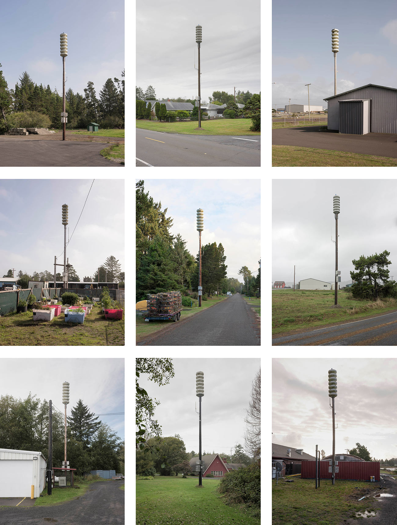
Matrix of tsunami siren towers, South Beach, 2020. Credit: Eirik Johnson
While technological advances have suggested the possibility for cell phone alerts to replace this physical infrastructure, AHAB siren towers remain a vital means for all people within the tsunami inundation zone to receive a warning in the event of a tsunami.
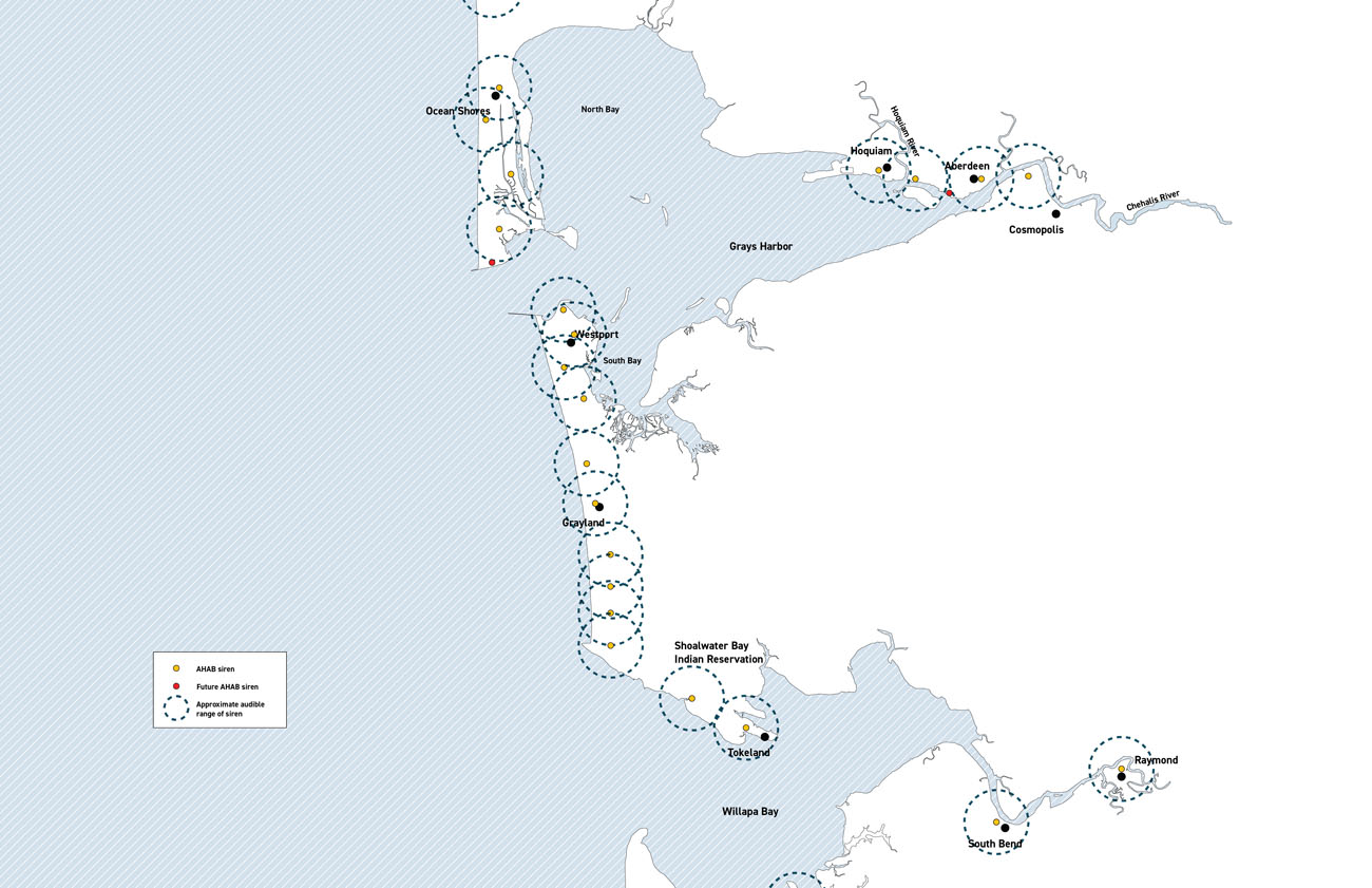
Mapping the existing system of tsunami siren towers. Credit: Cory Mattheis and Karen Duan/Robert Hutchison Architecture
While the infrastructure resembles a typical telephone pole, the AHAB siren tower is instantly recognizable by a series of seven stacked disc speakers mounted at the top of the pole.
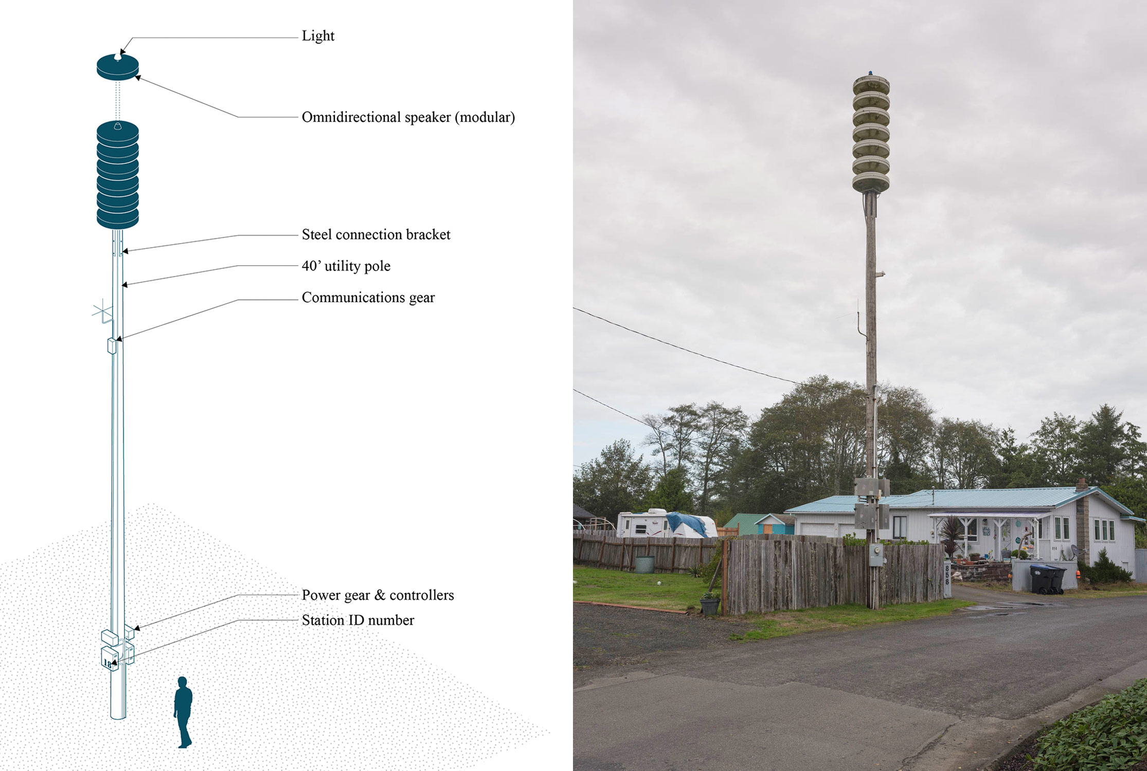
Left: Tsunami siren tower diagram. Credit: Cory Mattheis. Right: Tsunami siren tower on the outskirts of a private residence in Westport. Credit: Eirik Johnson
Tsunami Evacuation Maps
For areas that are at risk for a tsunami, the Washington State Department of Natural Resources and the Washington Geological Survey have completed tsunami evacuation routes to assist residents and visitors in finding safer locations in case of an earthquake and tsunami.
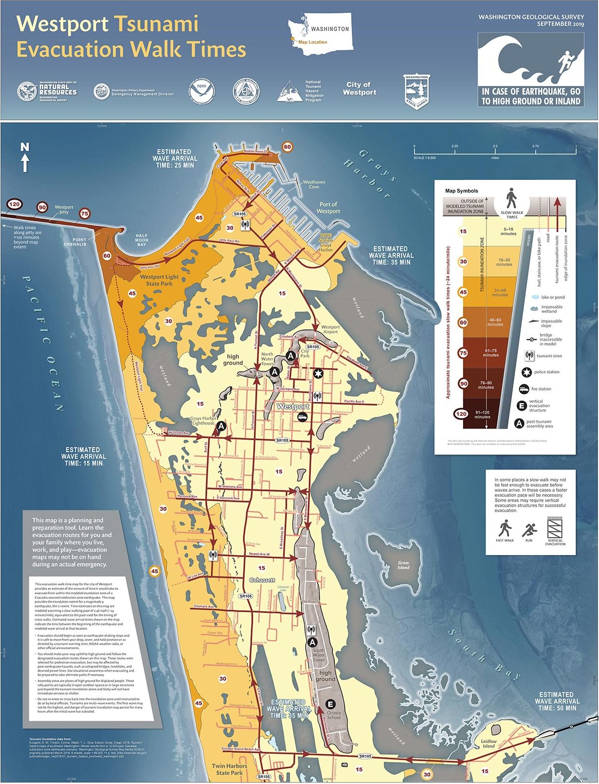
Westport Tsunami Evacuation Walk Times, September 2019. Credit: Washington State Department of Natural Resources, the Washington Geological Survey, the Washington Military Department Emergency Management Division, the National Tsunami Hazard Mitigation Program, and the City of Westport. Map courtesy of the Washington State Department of Natural Resources
Lighthouses
Lighthouses have served as critical navigation infrastructure for vessels trying to enter Grays Harbor and Willapa Bay.
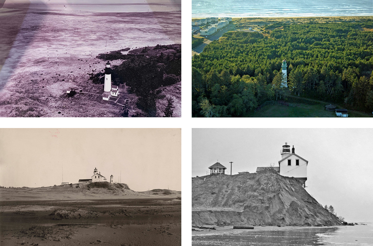
Clockwise from top left: Historic aerial of Grays Harbor Lighthouse, circa 1950; current aerial of Grays Harbor Lighthouse, circa 2020; Willapa Bay Lighthouse, lost to shoreline erosion in 1940; Willapa Bay Lighthouse, circa 1900. Courtesy of the Westport South Beach Historical Society
The Willapa Bay Lighthouse was constructed in 1858 in Shoalwater Bay, but was lost to shoreline erosion in 1940. The Grays Harbor Lighthouse was constructed in 1898.
The sites for both structures reveal the dynamic environment along this coastline. When first built, the Grays Harbor Lighthouse was situated at the edge of the coastal dune, directly exposed to the Pacific Ocean, yet today it is enveloped by a forest of invasive pine trees planted in the 1970s. The Willapa Bay lighthouse site, located along one of the most eroded coastlines in North America, is now completely submerged.
The octagonal Grays Harbor lighthouse is the tallest in Washington state. In 2004, the Westport South Beach Historical Society was granted ownership of the lighthouse.
The Grays Harbor Lighthouse is a 107-foot tall octagonal masonry tower. The thick brick masonry walls taper on the exterior as they rise from the base while maintaining a cylindrical void within. The Fresnel lens, manufactured by Henry-Lepaute of Paris, is accessed by a series of rotating spiral stairs that span from landing to landing, minimizing anchor points to the masonry walls.
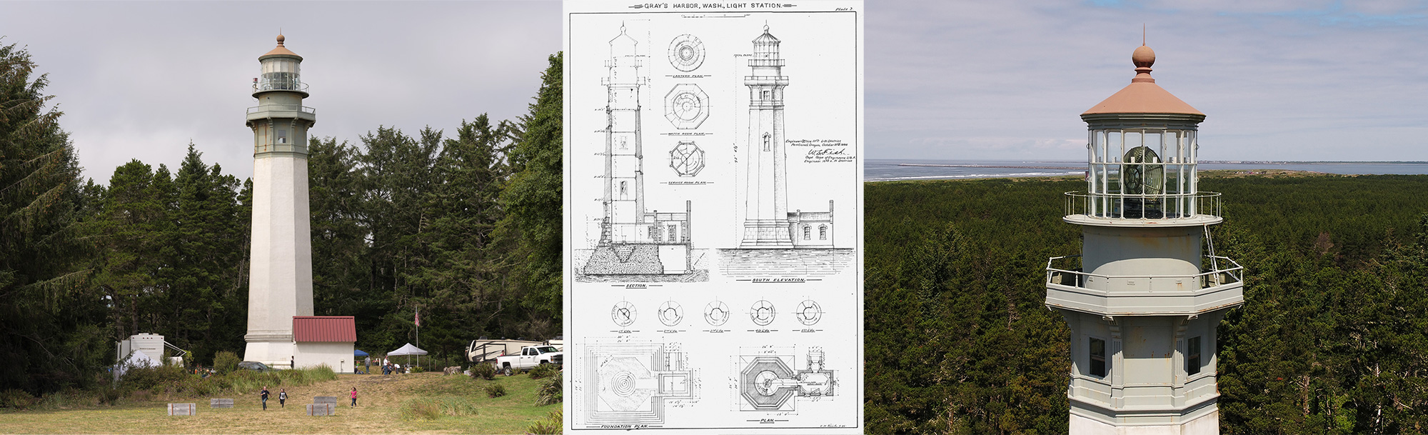
Left: Grays Harbor Lighthouse. Credit: Eirik Johnson. Middle: Historic drawings of Grays Harbor Lighthouse. Courtesy of the Westport South Beach Historical Society. Right: The view from Grays Harbor Lighthouse, overlooking the new, invasive forest. Courtesy of the Westport South Beach Historical Society
“The walls at the base of this octagonal structure are four feet thick, tapering up to an 18 inch width. They are made up internally of red brick and coated with concrete on the inside and outside. A metal structure completes the top of the tower.
There are 135 steps leading up to the lantern room. The staircase is original and forged of cast-iron. The manufacturer of the metalwork was Patrick Dundon of San Francisco Boiler Works. The landing brackets are pieces of artwork themselves. They are mounted to the wall to support the landings; the staircase is self supporting (sic).”
—Westport South Beach Historical Society website
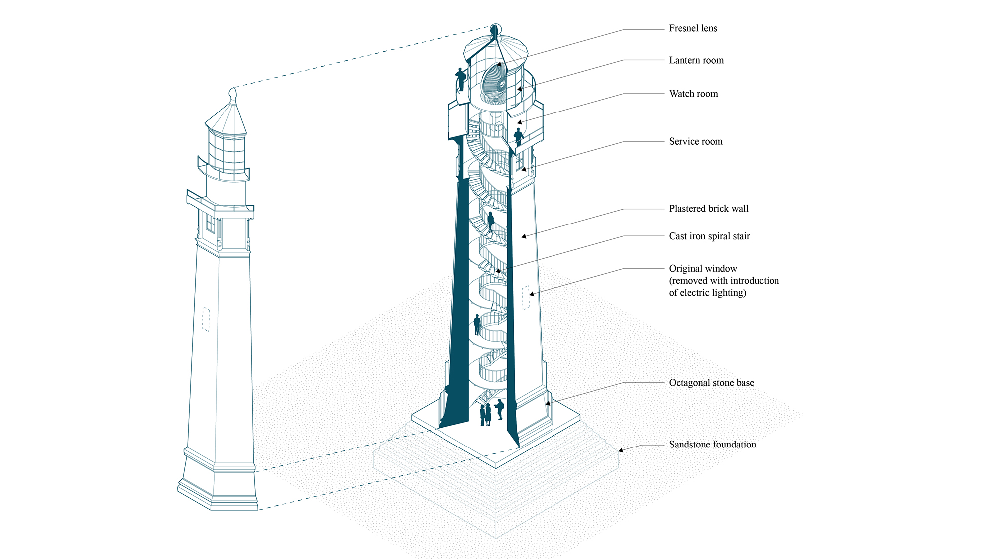
Cutaway axonometric of Grays Harbor Lighthouse. Credit: Cory Mattheis
Engaging Infrastructure
Westport Jetty
Two jetties (one north and one south) provide sheltered access to Grays Harbor and form a natural channel with outgoing tides.
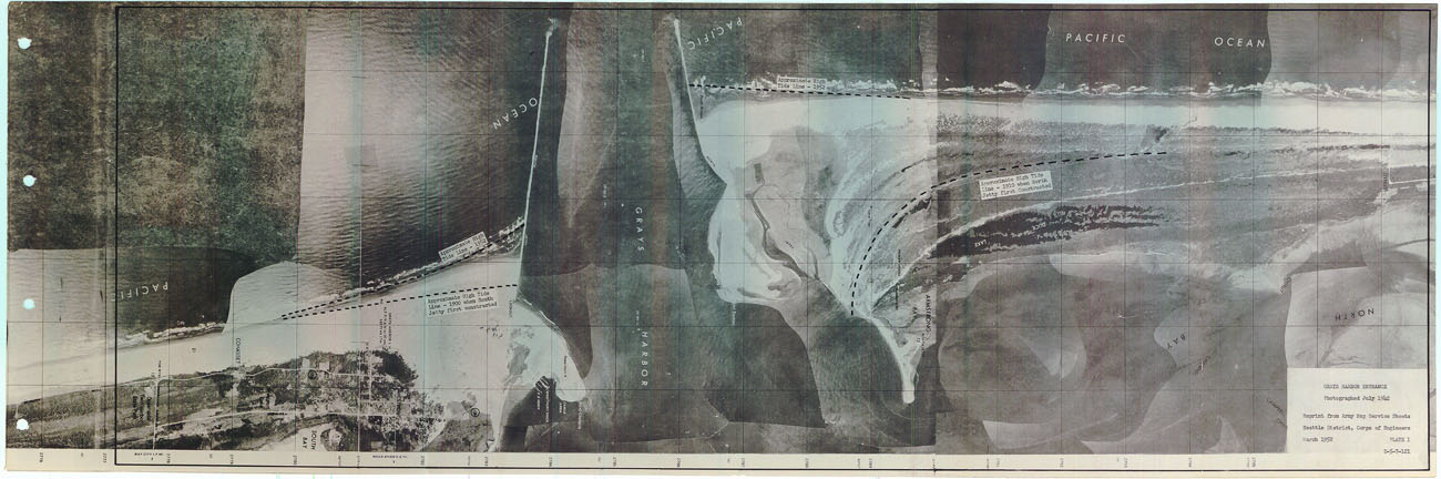
Composite photos of high tide lines in Grays Harbor entrance from 1910 and 1952. Courtesy of Westport Maritime Museum and Westport South Beach Historical Society
The south (Westport) jetty, completed in 1902, is over 17,000 feet long. Due to severe scouring that undermined the Westport jetty, another jetty was constructed on the north (Ocean Shores) side of the harbor entrance in 1910 to help protect the Westport jetty.
The jetties are supplemented by annual dredging of the channel.
“One particular entry we came across in detailed reading is by Head Keeper Christian Zauner on December 12, 1915, mentioning that he and the 1st Assistant Keeper made a measurement from the Fog Signal to the high tide line … 2750’ This was during a king tide cycle as measured locally. It was a long way to the water even back then. Just no trees or outer dune trail at the time.”
– John Shaw, Executive Director of the Westport South Beach Historical Society
1960–1970
The jetties continued to sink and by 1964 it was rebuild time again. Trucks carried the rock this time and modern machinery muscled the rock into place. This “rebuild” was very successful at creating the channelized flow of water on the outgoing tides that would scour the navigation channel to the desired depths without dredging …
1970–1990
Scientific discussions began to note that the lowering of the offshore bar had exposed the beaches immediately south of the jetty to heavier wave action. The beaches fronting on Westhaven Park began to erode, narrowing the strip of land between the ocean and Halfmoon Bay. There was uncertainty about whether the 1960s “rebuild” was too successful at creating scouring currents and it was suspected that the littoral currents altered by the construction in such a way that encouraged erosion … These questions began to be studied in more depth by a new host of agencies.
—Excerpted from “Our South Jetty,” a paper by John Shaw, executive director of the Westport South Beach
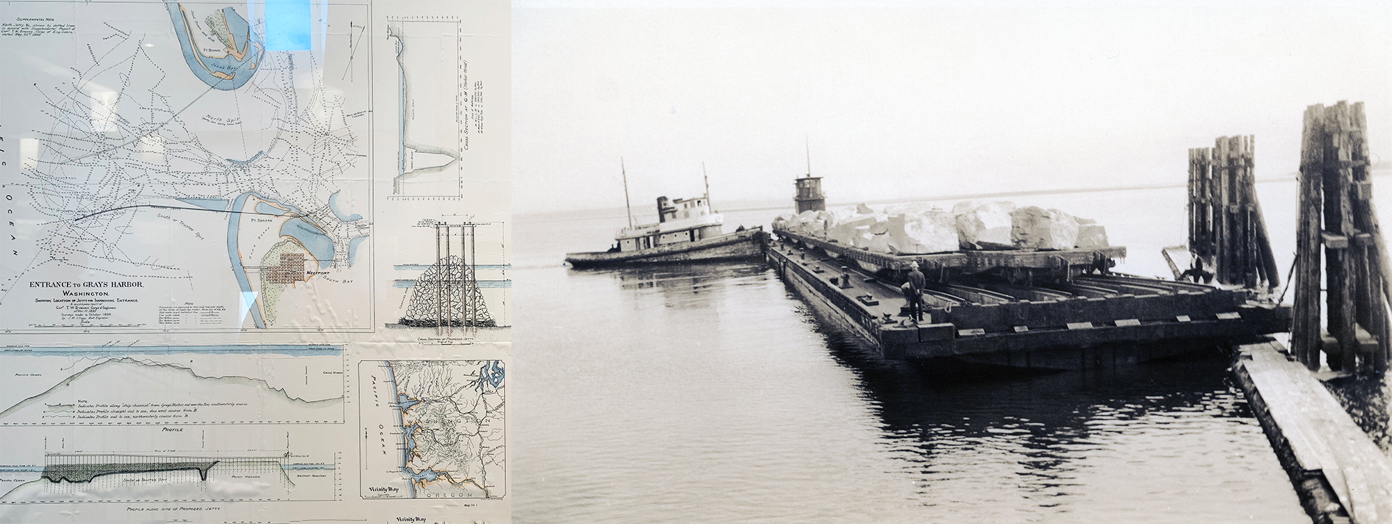
Left: Construction drawings for the South Jetty at the entrance to Grays Harbor. Right: Rebuilding the jetty by transporting barge stones across water. Courtesy of the Westport Maritime Museum and Westport South Beach Historical Society
Although no longer visible, below the entire length of the 17,000-foot-long South Jetty there lies the remains of a heavy timber trestle structure that was used for the construction of the jetty itself. The trestle structure supported two parallel railroad tracks that allowed for construction access as the jetty was constructed from the beach out into the ocean. At the leading edge of the trestle construction was a pile-driving apparatus that drove long timbers into the sandy sea bottom. This was followed by a trestle-framing and track-laying crew who laid the framework for train cars to move. Before any rocks were dropped, a thick layer of brushwood sticks bundled into “mattresses” was submerged to act as a foundation of sorts. This mat kept the large boulders from sinking into the soft sandy base. Train cars loaded with boulders were then sent out along the trestle and their contents dumped off the side to build up the rock jetty around the trestle.

Left: Historic jetty construction, where rubble and rock are dropped off the sides of a railcar. Courtesy of the Westport South Beach Historical Society. Right: Chart outlining the shoreline and bar changes at the Grays Harbor entrance from 1930 to 1951. Courtesy of the Westport Maritime Museum and Westport South Beach Historical Society
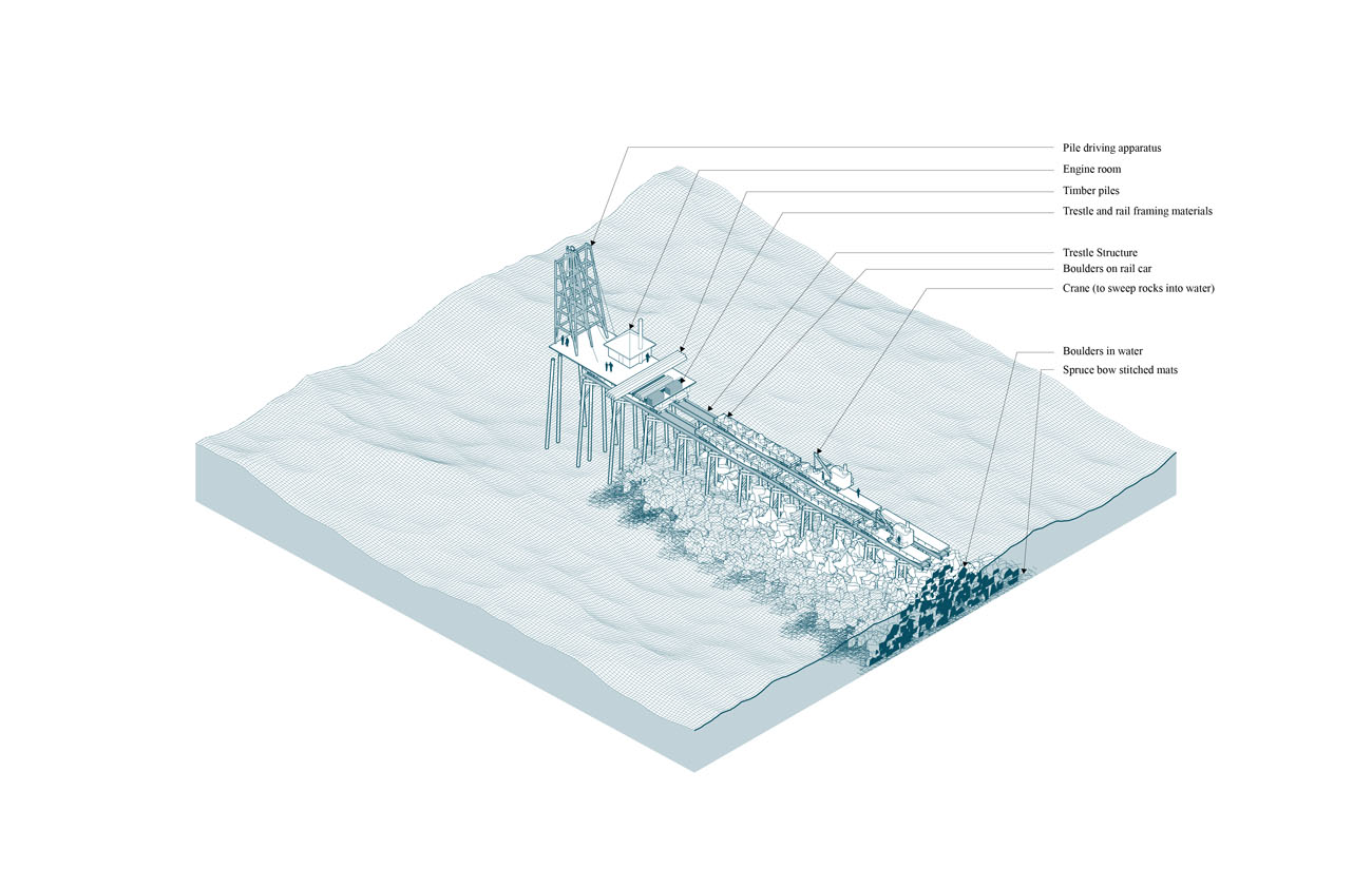
Westport Jetty. Credit: Cory Mattheis
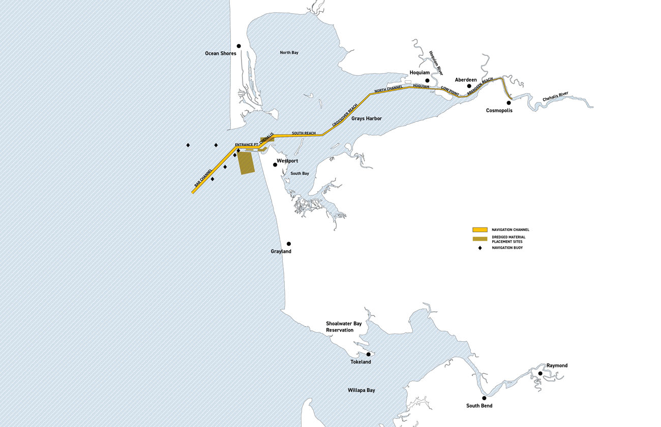
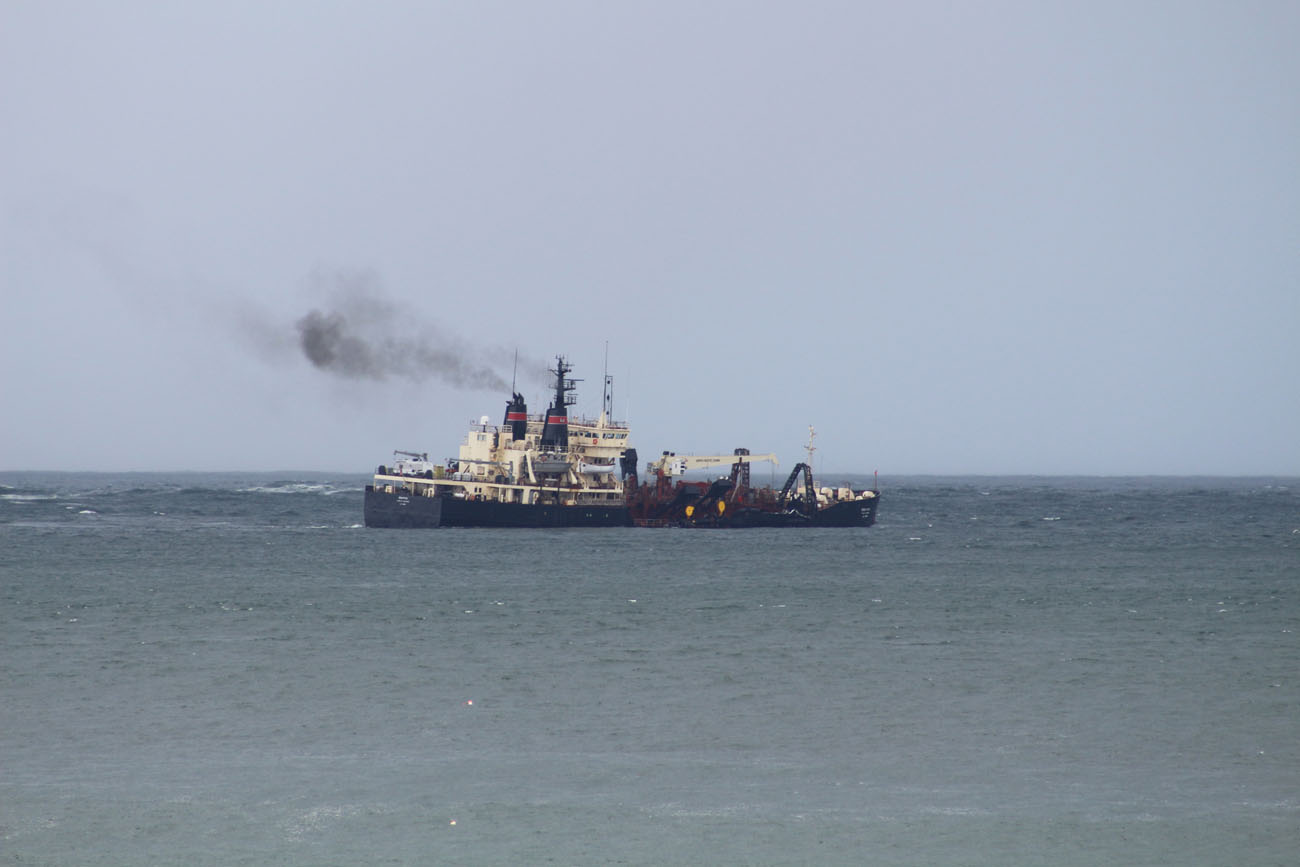
Dredging Vessel
Dredging vessels perform routine maintenance of the navigation channels into Grays Harbor, accessing ports in Westport and Aberdeen. This cut-and-fill process provides for navigation channels while reinforcing existing jetties that have been constructed to assist in safe passage.
Left: Grays Harbor navigation channel. Credit: Cory Mattheis and Robert Hutchison. Right: Dredging vessel in Grays Harbor. Photograph courtesy of John Shaw
Willapa Bay is no longer maintained as a navigation channel.
Dredging is an invisible underwater cut-and-fill process that involves the relocation of sand on a scale.
Trailing suction dredging vessels remove sand from shipping channels and relocate the sand in beneficial zones for accretion.
The animation below articulates the cut process, where suction arms pump up sand to the hoppers in the hull, and the fill process, showing the trailing section dredging vessel dumping sand in beneficial accretion areas.
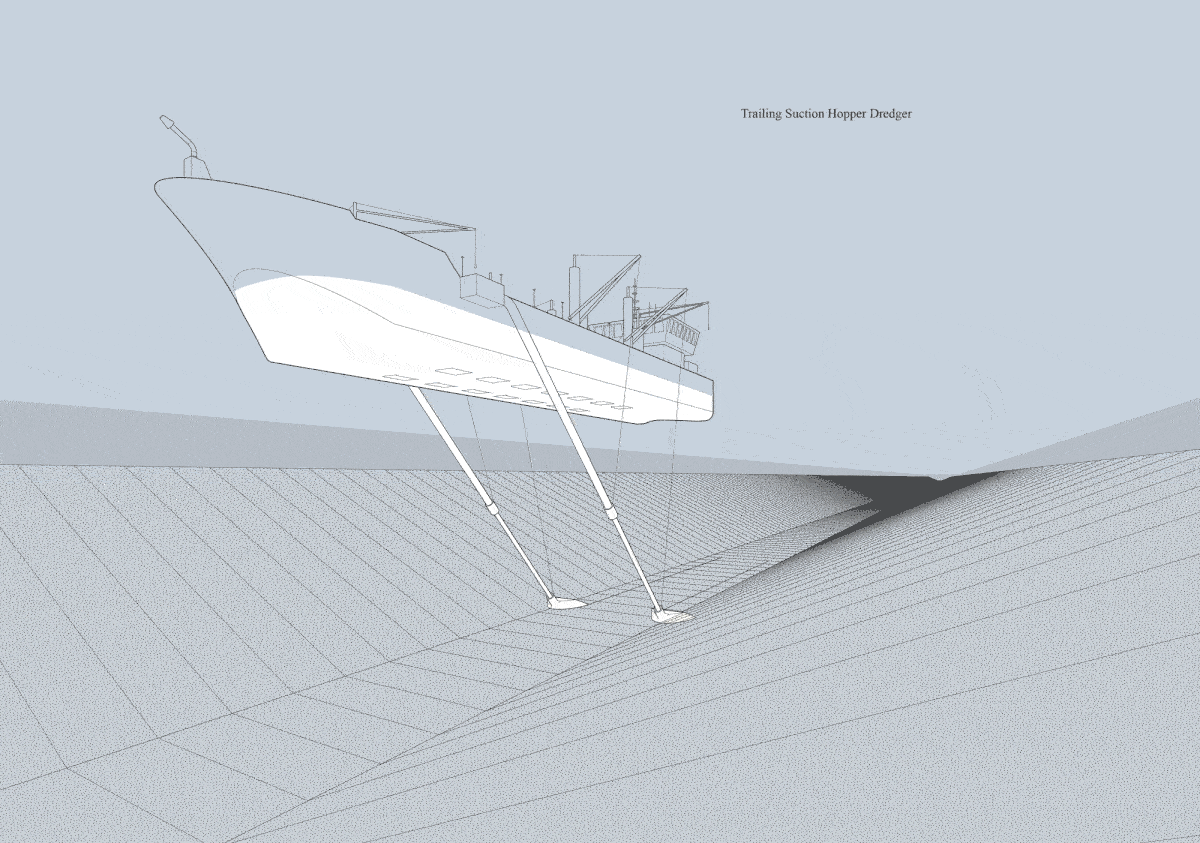
Credit: Cory Mattheis
Shoreline Stabilization
Cape Shoalwater extends from the town of Tokeland at the mouth of Willapa Bay to the small community of North Cove (more recently nicknamed Washaway Beach).
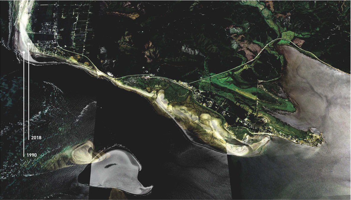
Composite image of shoreline transformation over 28 years. Credit: Cory Mattheis and Robert Hutchison Architecture
It is considered one of the fastest-eroding shorelines in North America. The composite image above shows transformation of the shoreline over 28 years.

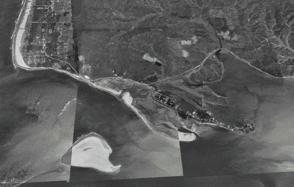
Coastal erosion along Shoalwater Bay. Photographs by John Shaw with graphic overlay by Cory Mattheis
The above timeline of photographs taken by John Shaw over the course of less than a year illustrates the extreme erosion occurring along the Shoalwater Bay coastline, and stabilization attempts by the Army Corp of Engineers.
The dynamic coastline of Shoalwater Bay. Credit: Cory Mattheis and Robert Hutchison Architecture
Sheltering Infrastructure
Vertical Evacuation System
The South Beach community, with its close proximity to the offshore Cascadia subduction zone, is susceptible to a potential large-scale tsunami following a magnitude 9 or greater earthquake. Inundation models of such an event show that communities along the Washington coast may have only 15 to 20 minutes to prepare for a tsunami wave that could reach 60 feet in height.
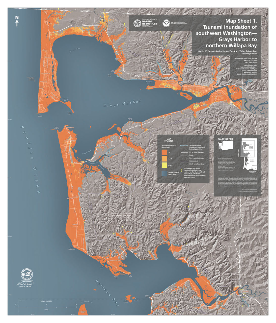
Tsunami inundation of southwest Washington Grays Harbor to northern Willapa Bay, March 2018. Credit: Washington Geological Survey Map Series, Tsunami hazard maps of southwest Washington. Model results from a ~2,500 year Cascadia subduction zone earthquake scenario by Daniel W. Eunguard, Corina Forson, Timothy J. Walsh, Edison Gica, and Diego Arcas. Courtesy of the Washington State Department of Natural Resources, Washington Geological Survey
In the event of a tsunami, there will likely not be sufficient warning time for communities to evacuate to high ground. Vertical evacuation structures (VES) strategically located in relationship with tsunami evacuation walking routes provide evacuees short-term protection above the level of tsunami inundation, and are designed and constructed with the strength and resiliency required to resist the effects of tsunami waves and debris. The South Beach community is the first in North America to execute this vital infrastructure typology.
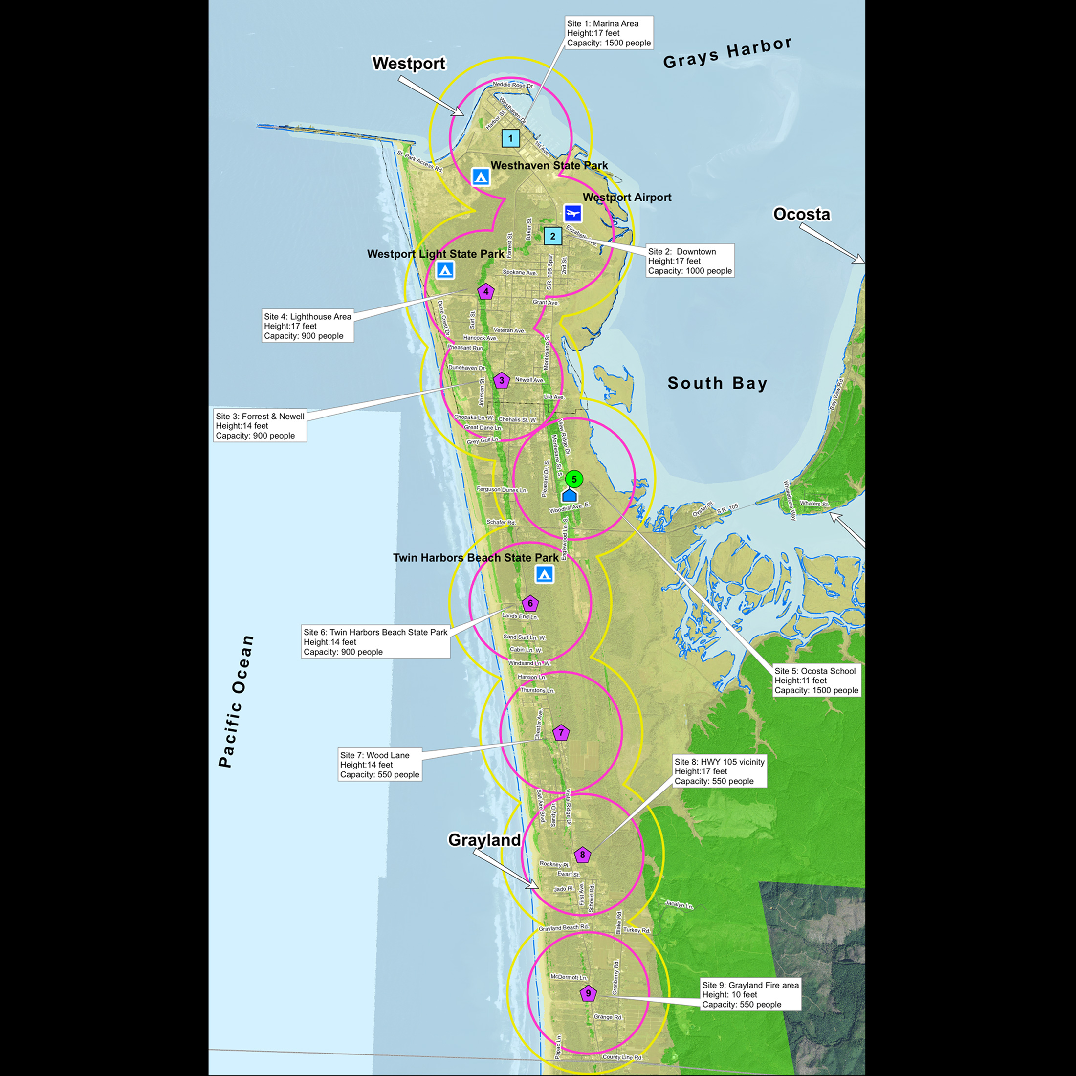
Map of future vertical evacuation systems for South Beach. Courtesy of Bob Freitag and Project Safe Haven, Grays Harbor County Emergency Management, “Project Safe Haven: Grays Harbor County,” 2011
Ocosta: Vertical Evacuation System
Completed in 2016, the Ocosta elementary school gymnasium is the first vertical evacuation shelter built in North America.
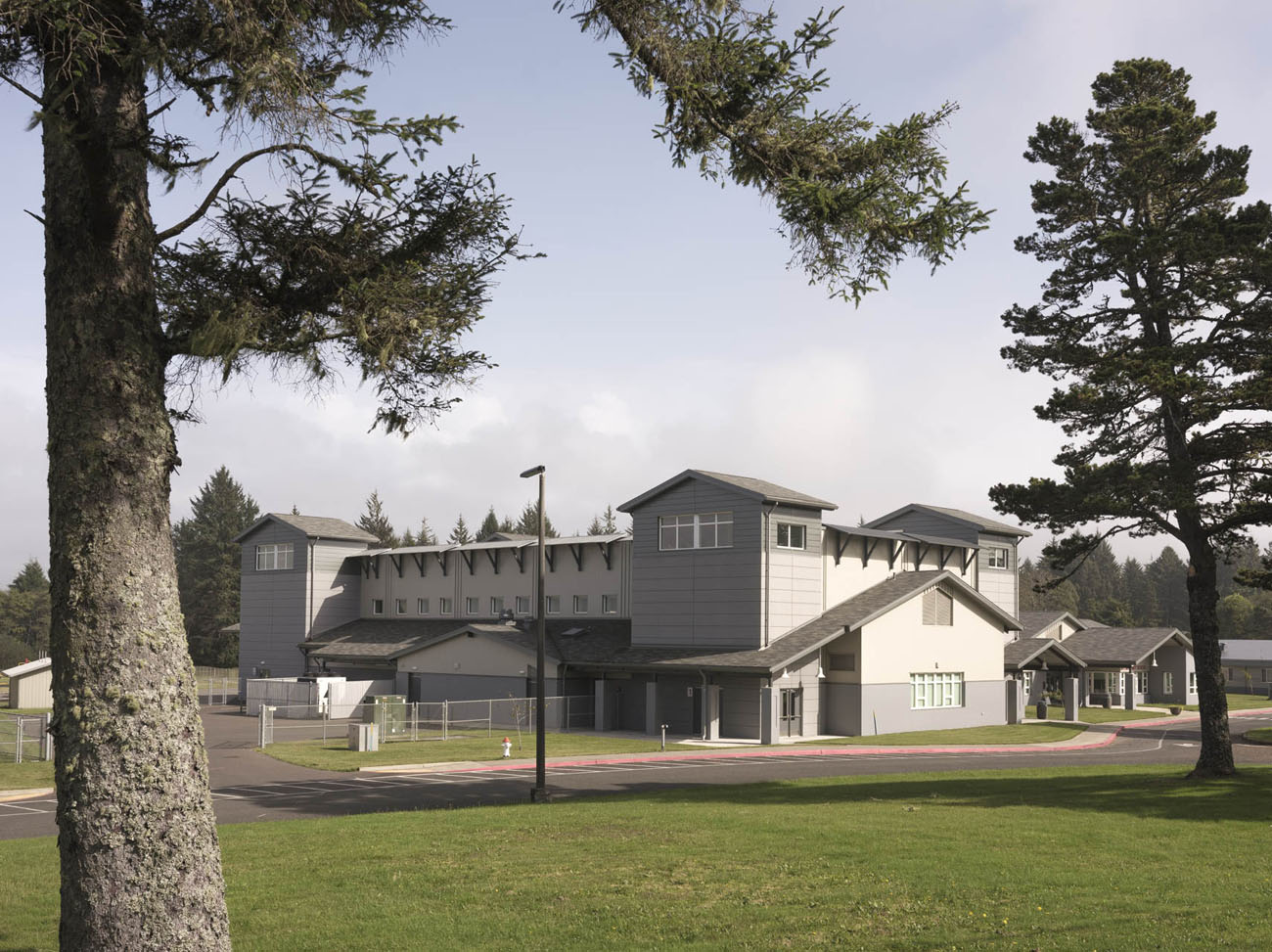
Ocosta High School, home to the first US Vertical Evacuation System, located in Westport, Washington. Credit: Eirik Johnson
Prompted in part by Project Safe Haven, a planning effort launched by local and federal government agencies to identify possible tsunami shelter areas along the Washington coastline, the community of Westport voted to approve additional construction costs to be allocated towards integration of a VES with the construction of the elementary school gymnasium. The structure is a source of pride for the community.

Isometric drawings of Ocosta Elementary School based on design by TCF Architects. Credit: Cory Mattheis
The structure is designed to withstand the forces of an earthquake and tsunami, as well as provide refuge for up to 2,000 students and community members on the gymnasium roof, which is elevated over 50 feet above sea level.
Evacuation stair towers at the four corners of the structure securely connect the roof to drilled pile foundations, while sacrificial facades between the stair towers are designed to wash away during a tsunami to reduce the lateral forces on the structure. It is estimated that the additional investment in structure and foundations for the VES resulted in an increased construction cost of less than 15 percent of the original cost.
“The vertical evacuation structure we are in right now is a testament to this community’s commitment to keeping their children safe. This was a community-driven process end-to-end. I can’t tell you how much I admire the people of South Beach for making this happen. In January 2012 the school board asked us to put together a facilities plan, and a committee to assess facilities needs. After a year, our committee was ready to suggest a new elementary school to replace the original building, and to incorporate a vertical evacuation structure … Below and around us are over one hundred 50-foot-deep pilings that will hold the building in place, with 50,000 pounds of rebar and 14-inch-thick concrete. The building will withstand a 9.2 magnitude earthquake, repeated tsunami waves, and battering from cars, and it will hold up to 2,000 people. This is an incredible story of a community that put public safety and public education together to build the first-of-its-kind vertical evacuation structure in the country.
—Paula Akerlund, former Superintendent of Ocosta School District, at the 2018 Coastal Resilience Workshop
Prototypical Vertical Evacuation System
Vertical evacuation structures are a developing infrastructure typology, with numerous structures constructed in Japan following the 2011 Tohoku earthquake and resulting tsunami. The typology presents unique design challenges, both structural and architectural.
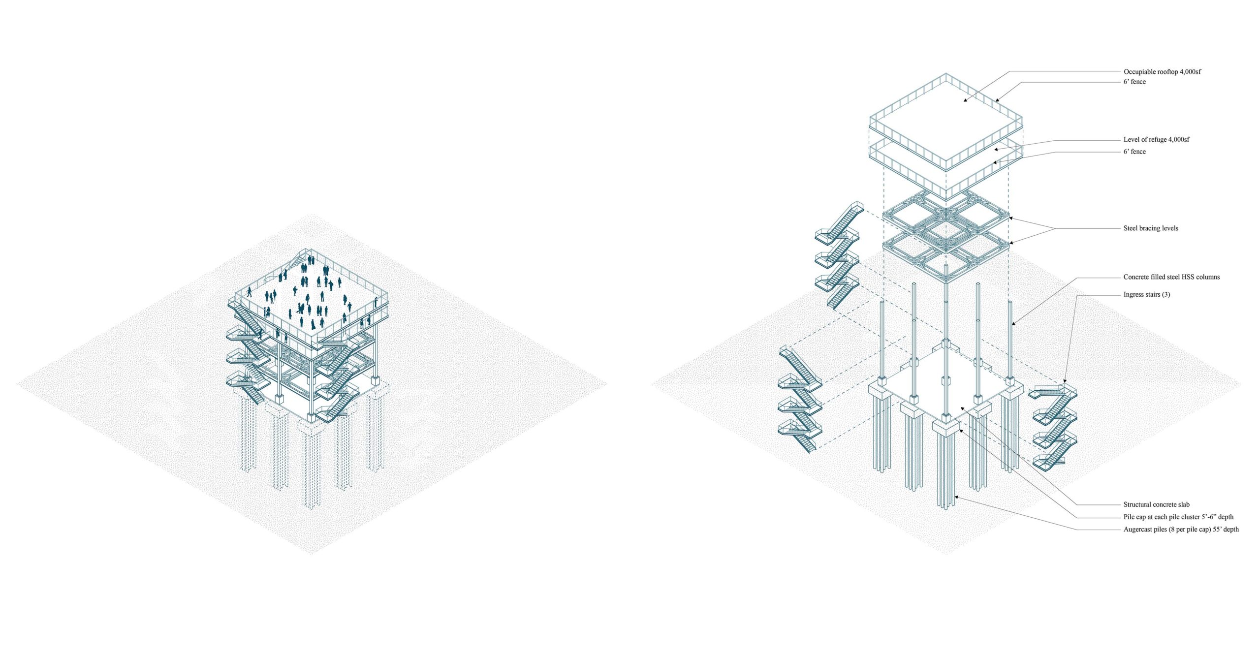
Isometric drawing of prototypical VES tower based on designs developed by Rice Fergus Miller & Degenkolb Engineers. Credit: Cory Mattheis
All vertical evacuation structures share components that include:
- ingress stairs and ramps that allow for the rapid evacuation of numerous people in a short period of time
- a substantial but porous structural system designed to withstand earthquake and tsunami loads, and
- one or a series of elevated platforms situated above the anticipated tsunami inundation wave height.
Designing a vertical evacuation structure involves a counterintuitive process. The primary structural system has to withstand the extreme lateral loads from an earthquake, tsunami debris, and wind that the tall structure is subjected to, while the evacuation platforms must be designed to support the substantial gravity loads imposed by numerous people during an emergency. Most unusual of all, tsunamis create hydrostatic forces when water pushing into a structure presses upwards on floors and roof, threatening to pull the structure out of the ground. Providing as large an evacuation platform for as many people as possible increases the structural requirements and ingress stair access points. The desire to maintain as much porosity at ground level to allow for tsunami waves and debris to pass through is in opposition to the structural and access requirements.
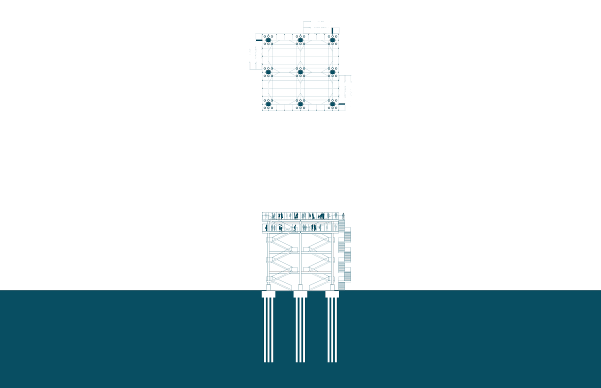
Section and plan animation of prototypical VES tower based on designs developed by Rice Fergus Miller & Degenkolb Engineers. Credit: Cory Mattheis
Since most vertical evacuation systems are designed solely as evacuation infrastructure, designers are also challenged with preventing unauthorized access to the tower during non-emergency conditions while providing means for access by all in the sudden event of emergency.
Because the infrastructure requires large investments for the sole purpose of an event that may not happen during the structure’s lifespan, and given that the structures are designed to accommodate large numbers of people, some communities have begun to consider how these structures could be designed to accommodate additional uses, providing the opportunity for greater value to the community and connecting the infrastructure to the community through daily use.
South Beach leaders are currently planning for several additional vertical evacuation structures to be constructed in the coming years. The City of Westport identified four sites for future structures, and the largest of these is currently in design, to be sited in the downtown marina district. Financing remains the biggest challenge, with an estimated construction cost between $1 million and $1.5 million. The city is considering ways to incorporate features that will allow the structure to be used for more than just emergency infrastructure, such as a covered stage for public events.
The irony is that these infrastructures are designed for a potential disaster with the hope that they will never need to be used. Through an imaginative reconfiguration of everyday engineering solutions combined with fresh programmatic thinking, the opportunity exists for future infrastructures that are directly integrated into the everyday lives of the communities that they serve, contributing towards resilient and cohesive communities capable not only of surviving natural disasters, but thriving before disaster strikes and recovering more quickly after.

Future vertical evacuation structure site in Westport, Washington. Courtesy of Rice Fergus Miller (RFM) Architecture
◊
The authors would like to thank the following individuals for their contributions to this piece: Kevin Goodrich, public works director for the City of Westport; John Shaw, executive director of the Westport South Beach Historical Society; Cale Ash, Degenkolb Engineers; Heejae Yang, Degenkolb Engineers; Brian Ho, TCF architects (Ocosta Elementary School).
Biographies
Cory Mattheis
is an architect and an associate at The Miller Hull Partnership, where he has served as lead designer on governmental, public, infrastructural, and residential projects. He has collaborated with Robert Hutchison on several conceptual projects that investigate the relationship of infrastructure and typology to urban and rural conditions. Since 2010 he has been working on an ongoing documentation of Mexico City billboard structures and their relationship to the urban fabric of the city.
Robert Hutchison
is a practitioner, researcher, and educator whose interests and practice overlap the fields of architecture, installation, and photography. He is principal of Robert Hutchison Architecture, and an affiliate associate professor in the University of Washington Department of Architecture, where he teaches undergraduate and graduate studios. Since March 2019, when he traveled to the Sendai region of Japan as a UW Runstad Real Estate Fellow to study the topic of earthquake and tsunami resiliency, Hutchison has been researching the state of emergency preparedness for communities along the Pacific coast of Washington state that are subject to tsunami inundation. Most recently, Hutchison was selected as a 2020–21 Creative Artist Fellow by the Japan–US Friendship Commission. For this fellowship, he plans to travel to Japan in 2021 to study the relationship of recently constructed tsunami infrastructure to small communities along the Tohoku coastline of Japan.
The views expressed here are those of the authors only and do not reflect the position of The Architectural League of New York.