As humans, understanding the complex environments and timeline of change is something we are ill-equipped to do, given our short lifespans and the complicated interactions that define ecological systems.
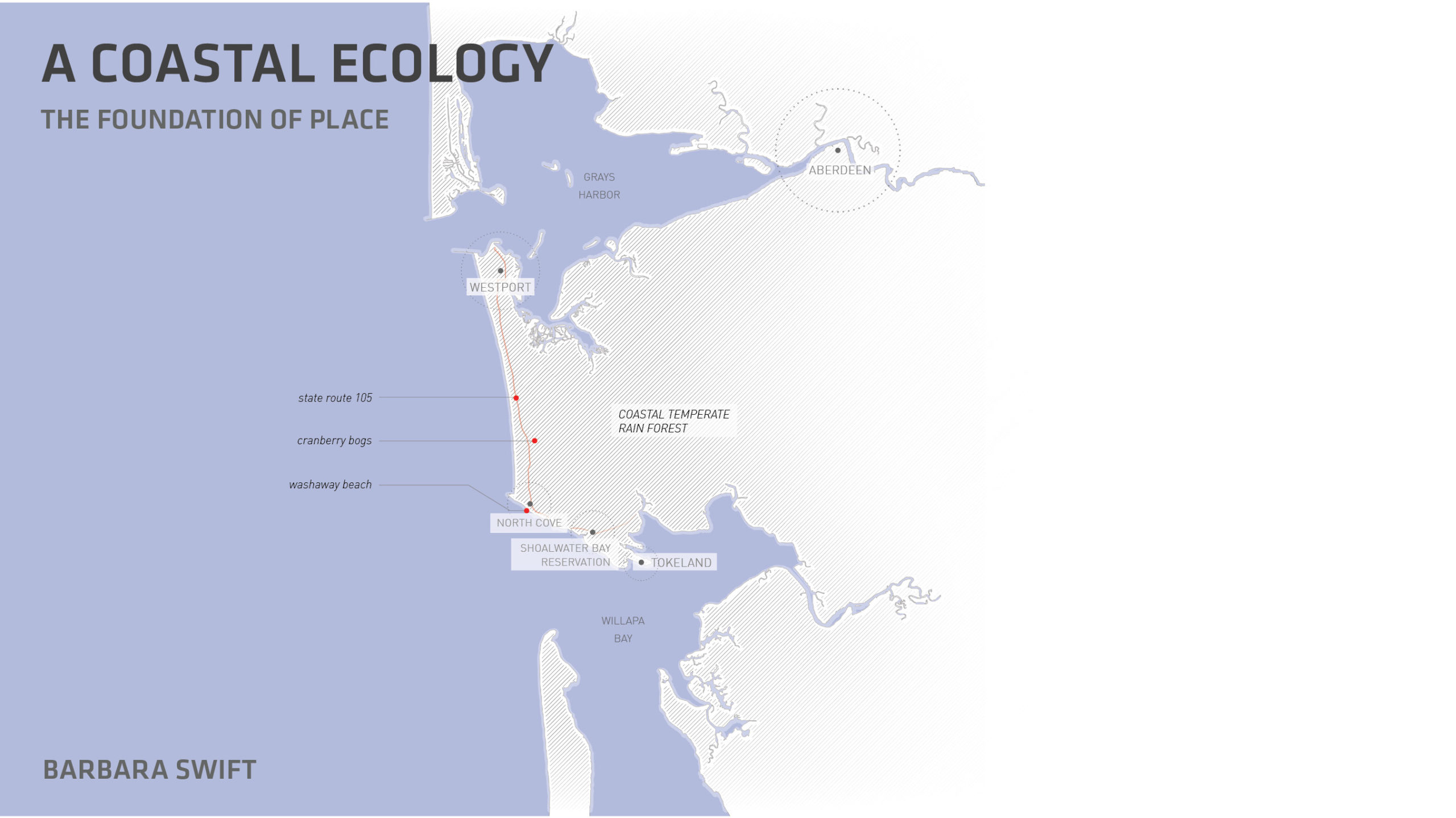
The Southwest Washington coast is exceptionally dynamic and fundamentally defines this place. We have selected two points of entry to understand this remarkable ecosystem. Each is a complex web of energy systems in constant motion. One defines the region with a time horizon of 100 years and the other illustrates dramatic annual change. This is the context for the relationship between the environment, individuals, and communities.
The first, coastal temperate rain forest, with its summer fog, is the foundation of this place and its identity. Everything springs from this exceptionally rich biological system of nutrient transfer from forest to sea and back. It is why this place has been occupied for millennia. It provides nourishment and economic development. It defines the way humans engage with infrastructure, and it creates a potent place connecting humans with regional identity.
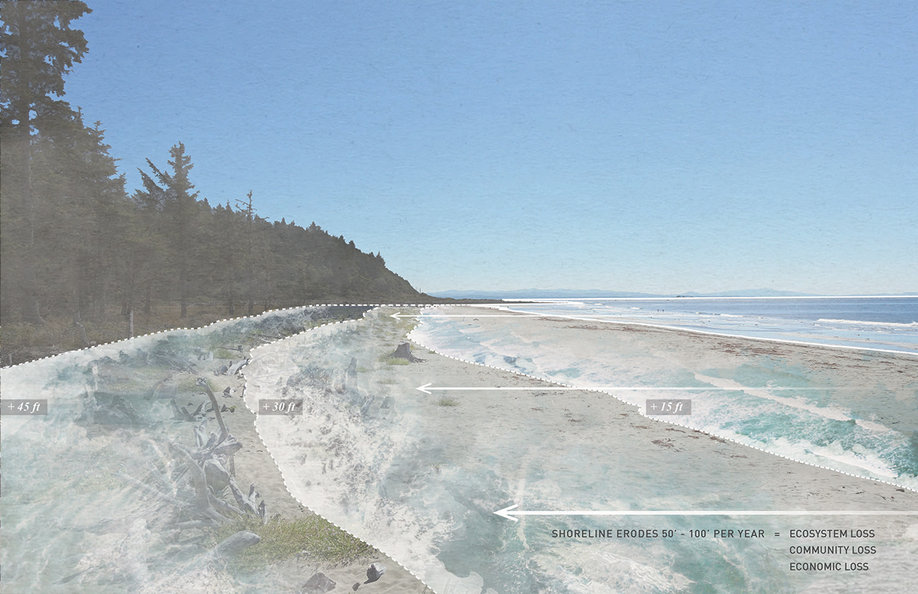
The second is a specific site, Washaway Beach and the adjoining cranberry bogs, where the collision of ocean and terrestrial systems results in the loss of 50 to 100 feet of beach every year. The loss of the beach and dune systems equals the future demise of the bogs. A galvanized community of homeowners and cranberry farmers is engaged in an ongoing experiment, working with the coastal systems to restore the beach and dune ecosystems. Here, the small community has engaged in close observation and experimental stewardship in partnership with a dynamic living system.
Through these two conditions, our intention is to provide access to an impossibly complex topic. Comprehending the critical thread between things creates a web of understanding, placing the pieces of the environmental puzzle in a larger structure. Both conditions illustrate the importance of paying close attention to place, with respect and curiosity for the environment. This creates a relationship of caretaking and humility founded on observation, interdisciplinary thinking, risk-taking, and knowledge that our approach to cohabitation might fail. The dynamic power of the landscape is intrinsically enmeshed in community life and creates a unique opportunity to understand the connections between complex ecosystems and community vitality.
All graphics by Karen Duan / Robert Hutchison Architecture and Barbara Swift, featuring photography by Eirik Johnson.
Coastal Temperate Rain Forests
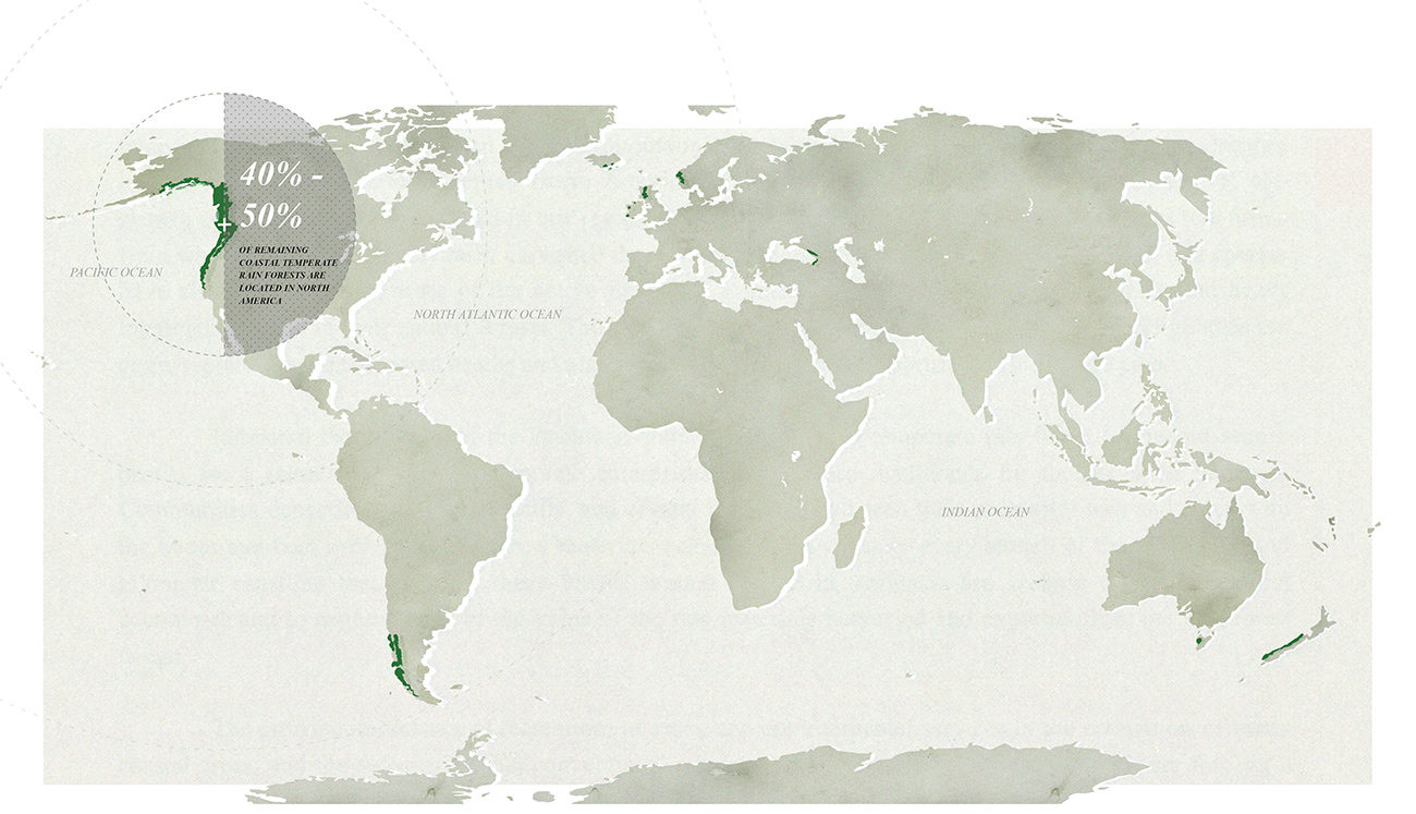
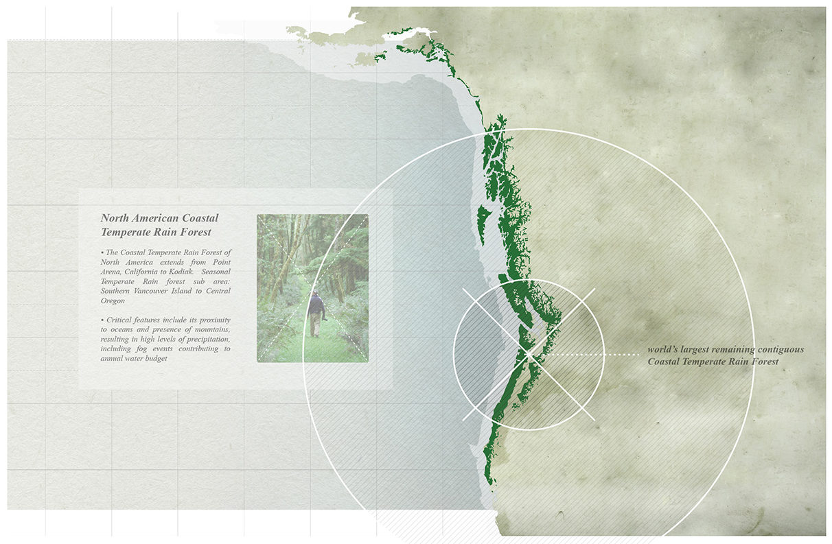
Coastal temperate rain forests cover less than one fifth of 1 percent of the Earth’s surface. The largest such rain forest resides in North America.
Coastal Temperate Rain Forest: Facts & Figures
- Worldwide extent: 74-99 million acres
- North American extent: The coastal temperate rain forest extends from Point Arena, California, to Kodiak, Alaska. The seasonal temperate rain forest sub-area extends from central Oregon to Southern Vancouver Island.
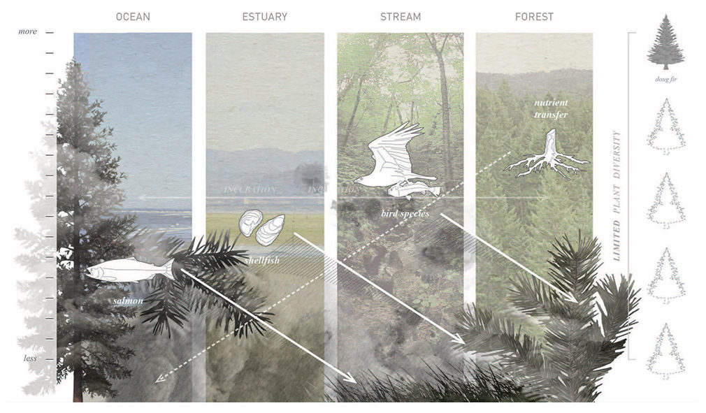
- Ecological characteristics: Areas where the land meets the sea are the most complex and dynamic systems on Earth, comprising terrestrial, freshwater, estuarine, and marine ecosystems, with above-average water salinity, vegetation, and species change. The two systems of forest and sea are interlinked with an exchange of nutrients and energy and form the basis of a complex food chain.
In the Southwest Washington coast region, species include Sitka spruce, yellow cedar, hemlock, and Douglas fir, with coastal redwood to the south.
- Critical features:
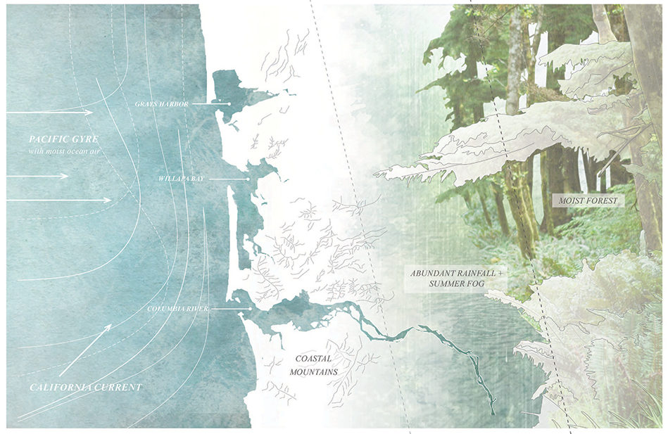
- Proximity to oceans, presence of mountains, and the result of these two: high levels of precipitation, including fog events that contribute to the annual water budget, creating an exceptionally productive and fecund environment
- Overabundance of moisture throughout the year and absence of catastrophic fire
- Weather driven by ocean currents moderating the California Current and the North Pacific Gyre: Winter storms driven out of the south and west collide with the coastal mountain cooler air. Water condenses into rain and makes its way to the sea through a network of riparian systems. In summer, the warm ocean air meets the cold coastal waters, resulting in fog events that provide critical moisture for forests during typically dry summers.
- Southwest Washington climate
- Temperature
- From June to October, average daily high of 62 degrees
- From November through February (the cool season), average daily high of 51 degrees
- Precipitation
- 98 inches of rain per year
- Wet months: 6.7 months per year
- Dry season: 5.4 months per year
- 126 sunny days
- Temperature
The Natural Forest
In a natural state, storm events result in windthrow (trees uprooted by wind) due to shallow roots, creating a patchy “mosaic” landscape and increased species diversity. Root systems are shallow due to the high level of nutrients and water at the surface. Windthrow events result in varied sunlight penetration and an increase in organic debris. This debris accumulates over centuries, increasing structural and species diversity.
Coastal temperate rain forests accumulate up to between 223 and 892 tons of organic material per acre, two to five times more than what is found in tropical rain forests. Climatic conditions result in reduced respiration transpiration demand, and in exceptional tree longevity and size. The abundance of moisture has historically eliminated the potential for catastrophic fire. The result is ecological stability and a constantly growing nutrient bank, creating a wide variety of microhabitats supporting a large array of plant and animal species, embodied as a significant carbon reservoir.
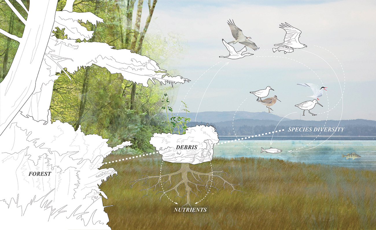
The coastal temperate rain forest supports incredible species diversity. This stems from its strong foundation in debris-found nutrients.
In its natural state, the diverse forest is but one part of a large energy-transport system that brings critical debris and nutrients to the estuaries through riparian corridors. As a result, estuarine areas associated with coastal temperate rain forests are some of the most productive in the world. The estuaries, in turn, become the incubators and nurseries for the forest and sea.
The coastal temperate rain forest can be equated to a bank, where critical nutrient deposits consistently build, supporting larger ecological vitality and resiliency. This is very different from current industrial forest strategy with short harvest cycles and limited tree species. The industrial forest strategy extracts material and reduces nutrient contribution; over time, the bank supporting the larger region is depleted.
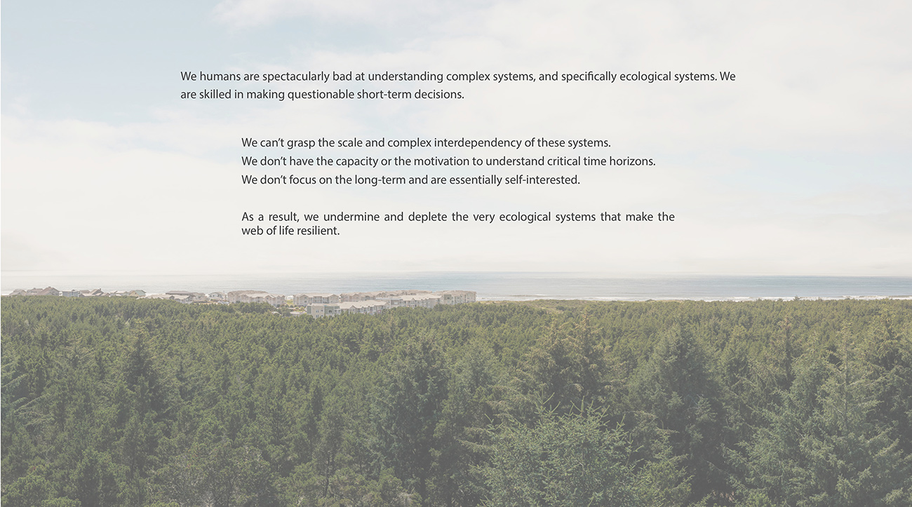
We humans are spectacularly bad at understanding complex systems, and specifically ecological systems. We are skilled in making questionable short-term decisions.
We can’t grasp the scale and complex interdependency of these systems.
We don’t have the capacity or the motivation to understand critical time horizons.
We don’t focus on the long-term and are essentially self-interested.
As a result, we undermine and deplete the very ecological systems that make the web of life resilient.
The Industrial Forest
Over time, limited plant diversity and the removal of trees in the industrial forest reduces debris deposition, resulting in nutrient reduction. This depletion of the debris and nutrient bank diminishes the resiliency and functionality of an exceptionally productive system of forest, estuary, and coastal waters. The web binding this system together becomes more fragile and less stable.
An industrial forest results in the depletion of both nutrients and species diversity.
The majority of the region’s forests have been logged multiple times, resulting in a reduction of tree species and readily visible impacts including increased erosion and stream sedimentation. The excessive planting of conifers has reduced flowering deciduous shrubs and trees, resulting in a reduction in ungulate, fish, insect and some bird food chains. In the face of future climate change and tsunamis, diminished ecological diversity will significantly influence the capacity of this complex system to renew and repair. The resulting action of such events will diminish the health of the coastal temperate rain forest, producing impacts for decades, if not millennia.
The Managed Forest
A managed forest allows for the careful harvesting of trees, while emulating the native coastal temperate rain forest. The result is a preservation of species diversity, patches of canopy openings, and deposition of debris that feeds the moving web of nutrients, allowing for the banking of nutrients that help the forest, estuary, and coastal waters weather the impacts of climate change and catastrophic events such as tsunamis.

A managed forest emulates the natural forest, resulting in an increasing nutrient bank.
Forest management strategies that increase diversity have 50- to 100-year management horizons. The actions people take today determine what the forest ecosystem will be like in future decades. Given the speed of climate change, immediate priorities include the nutrient web and introducing species that can withstand shifts in precipitation and temperature. These actions can become part of the foundation that sustains the health of the estuaries and coastal waters. This can result in a deeply resilient condition that has the capacity to respond to the complexity of future conditions.
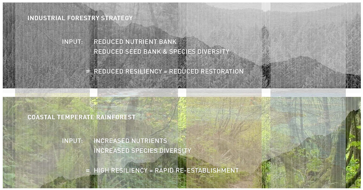
When major forces such as climate change, earthquakes, and tsunamis impact the forest ecosystem, its capacity to respond can be thought of as an equation: linking nutrients and species diversity. With the health of the forest comes the health and resiliency of the estuaries, coastal waters, and communities.
Beach and Bog
The story of beach and bog is one of large, consistently changing energy systems transporting huge amounts of material and debris. At the heart of the story is the interface of land and sea, where the collision of currents, tides, storms, and land creates rapid change over the period of a year or a season. The dramatic results of this interface stand in contrast to the almost invisible slow change occurring over seasons and years in the coastal temperate rain forest ecosystem. A review of both the rain forest and the beach/bog ecosystems can help us understand environments in motion and illustrate two ends of a spectrum of change.
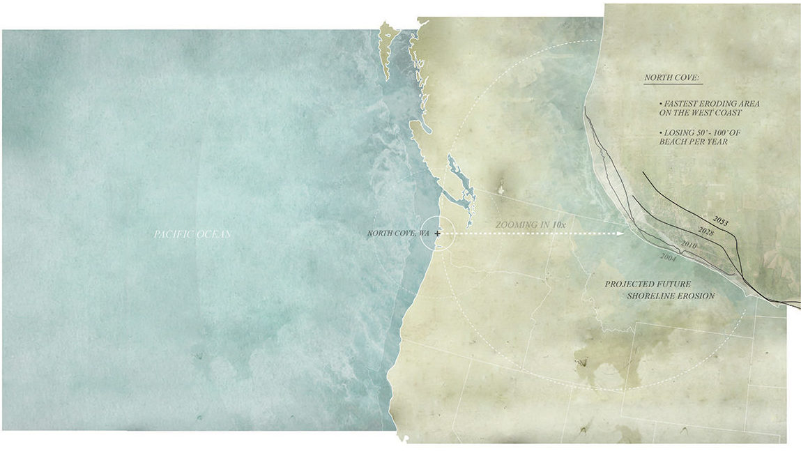
Beach and bog energy systems: Washaway Beach on Washington’s coast is the fastest-eroding area on the West Coast, rapidly losing between 50 and 100 feet of beach per year.
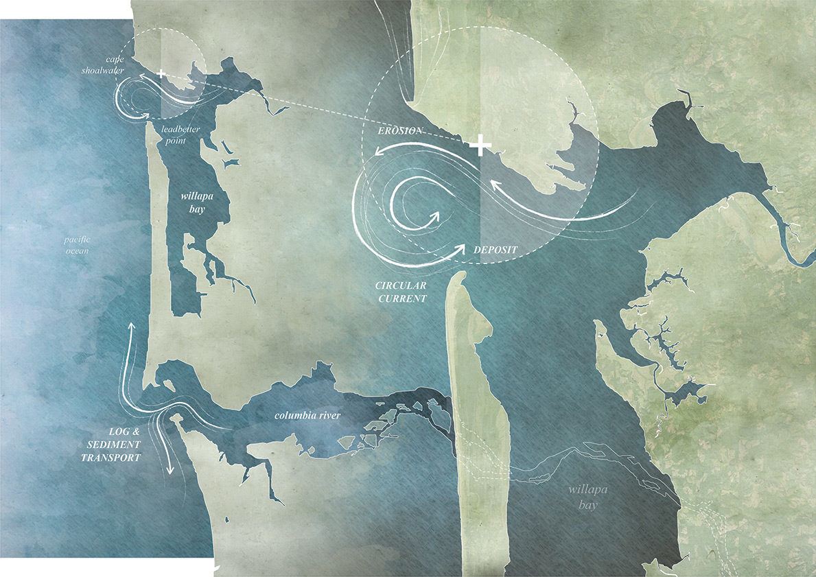
The Cape Shoalwater coastline at North Cove is subjected to extreme currents, tides, and storms. This results in rapid erosion over the period of a year or a season.
Beach and dune stability is dependent upon sediment transport. In the case of the Cape Shoalwater coastline, the beaches and dunes are fed by log and sediment transport from the south, with the Columbia River historically a significant source. This combination of logs and sand feeds the beach system, distributed by currents, storms, and tides. The beach and dune system, in turn, helps to protect inland bog lowlands from detrimental saltwater intrusion.
The story of beach and bog is also one involving humans and their impulse to live in highly dynamic ecosystems. The characters include the town of North Cove (a small town originally platted in 1884, large portions of which have been eroded by the ocean), the Grayland cranberry bogs (which support an industry that grew out of the native cranberry bogs), and State Route 105 (abandoned and bypassed in the 1990s due to severe coastal erosion). While the Shoalwater Cape coastline has historically experienced significant erosion on an annual basis, some have speculated that with river damming in the last century, the amount of sediment transport that feeds the beach and dune system has reduced, resulting in increased beach erosion. Since the rerouting of State Route 105, a group of people representing government entities, NGOs, local drainage districts, and community groups has been working together to restore the beach and dunes, in an effort to stabilize coastal erosion conditions that threaten the remnants of the town of North Cove, as well as the nearby cranberry bogs.
“Nature has a hundred different ways to build a stable beach. We began to realize that the most critical thing is the beach slope and angle. If you don’t have a slope that is appropriate to the wave and that extends up to and above the storm zone, then you are going to have a collision and you are going to lose your beach.” —Connie Allen and David Cottrell of Wash Away No More during an August 2020 site visit
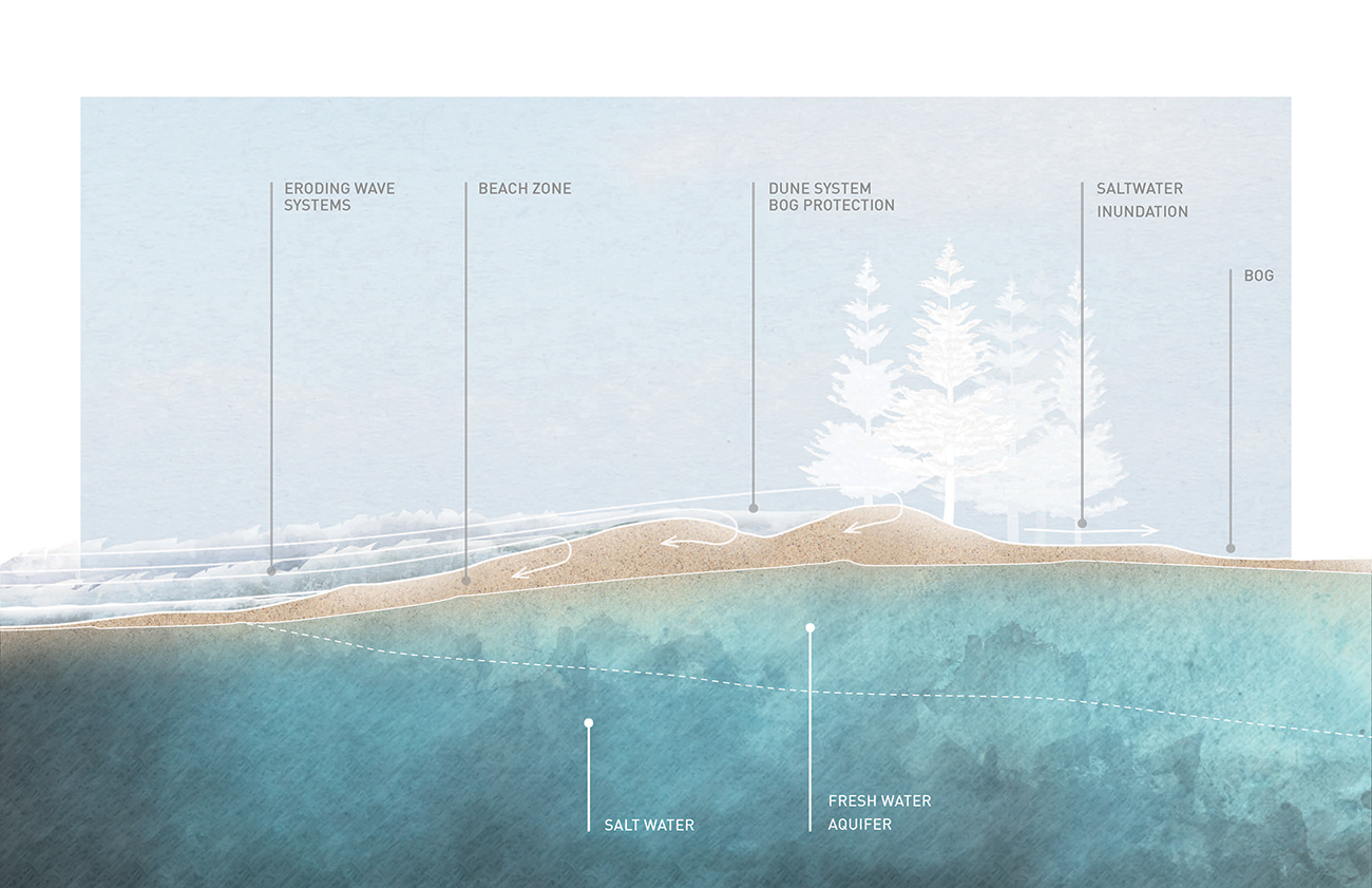
Beaches, with their dune systems, allow bogs to exist—they protect the bog’s plant community from saltwater inundation. The native cranberry bogs of South Beach have grown into a 150-year-old agricultural agency, bringing over six million dollars annually to the local community. In many cases farmed by multiple generations, the Grayland cranberry bogs have become a part of the community’s identity. They are dependent on the health of the beach and dune system. Dramatic coastal erosion threatens to undermine the resulting ecological, economic, and community stability.
“We have learned a bunch of tricks. The same waves that cause the most erosion—the high-energy and high-density waves—pick up a lot of sand in the near shore. If you can dissipate the energy and the wave has a suspended load, you are able to get it to drop the load. It is your dump truck.”
— Connie Allen and David Cottrell of Wash Away No More during an August 2020 site visit
Building beaches is an infinitely complex undertaking. Each reach of beach has a different system of currents, orientation to waves, and slope at play. The challenge is to observe and experiment using a set of tools to help these systems drop their sediment load on the beach instead of removing more. This means reducing the energy in the collision between land and water.
The dynamic tools of logs, cobbles, sorted rock, a shallow beach slope, and vegetation can incrementally be used to build a beach during summer months and protect it during winter storms. These tools move in response to the amount of energy present in the collision between water and earth and are redistributed along the beach section, reflecting the unique characteristics of each reach of beach. Incremental additions over years add up to create woven systems of plants, debris, and material that protect the bogs from saltwater inundation.
Experimental Physical Tools for a Living Shoreline

Beach building uses a set of simple, low-cost natural tools to dissipate wave energy and increase sediment deposit and retention. These tools move with the water, absorb wave energy, and reduce impact. Developed and closely managed by a community group under the umbrella of Wash Away No More, these experiments involve a rapid feedback loop of observation and modification.
Case Studies
The following case studies illustrate different beach reaches in the North Cove area and the experimental approaches employed to rebuild the beaches.
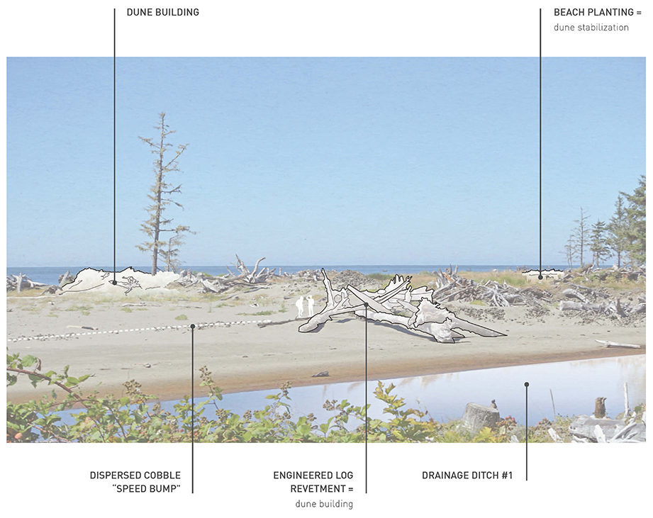
Blue Pacific Drive
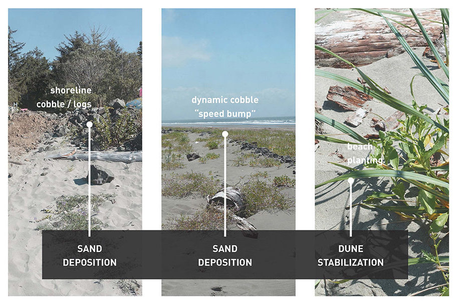
North Cove’s Blue Pacific Drive, along with numerous homes, used to extend to the west, but has been destroyed by an eroding beach line with a vertical escarpment. Beach rebuilding efforts have included armoring the escarpment with logs, rock, and movable cobble to slow the erosion and arrest wave energy. Winter storms contain particularly high energy, and the logs and rock serve as a defense in the shoreline energy zone. Lines of cobble “speed bumps” run along the beach and create a secondary armature, reducing wave energy and slowing the motion so that sediment is dropped among the cobbles. Beach plantings knit the sand and cobbles together with a root matrix, increasing the beach stability. Sand deposition flattens the beach slope, further dissipating wave energy and increasing sand deposition.
Old State Route 105: North Beach
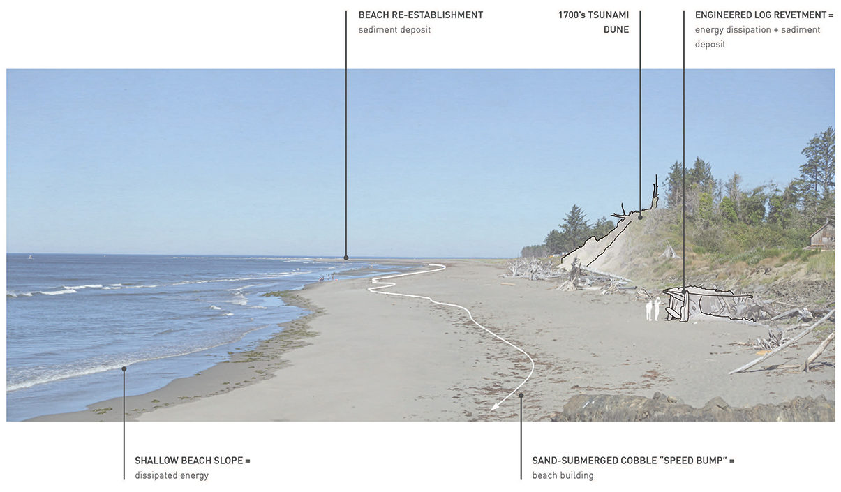
The orientation of this reach of beach faces into the southwest prevailing winds and sea swells, creating a higher-energy beach. Given this energy level, the extensive matrix of engineered logjams is critical to make a larger, more stable system that ameliorates wave energy and slows the water so sediments are dropped. Sand builds up among the logjams. Smaller cobble “speed bumps” are used to slow the waves and are eventually covered by sand.
This reach of beach is particularly susceptible to winter storms and has greater seasonal change in beach extent and slope.
Old State Route 105: South Beach
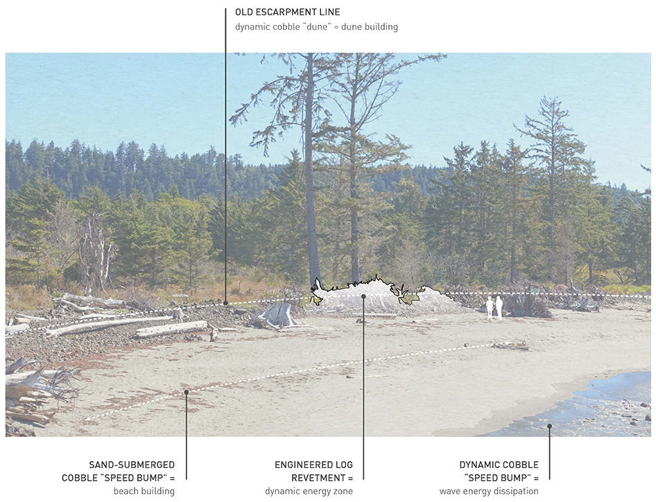
In addition to the tools of engineered logjams, rocks, plants, and cobble, a source of beach-building material is critical. Immediately north of this beach is a cobble bluff that has been intentionally enhanced to feed the high-beach-energy zone. The installation of a cobble upper beach with engineered logjams has resulted in sand deposition, and additional plantings stabilize the old escarpment line.
Smith Anderson Road
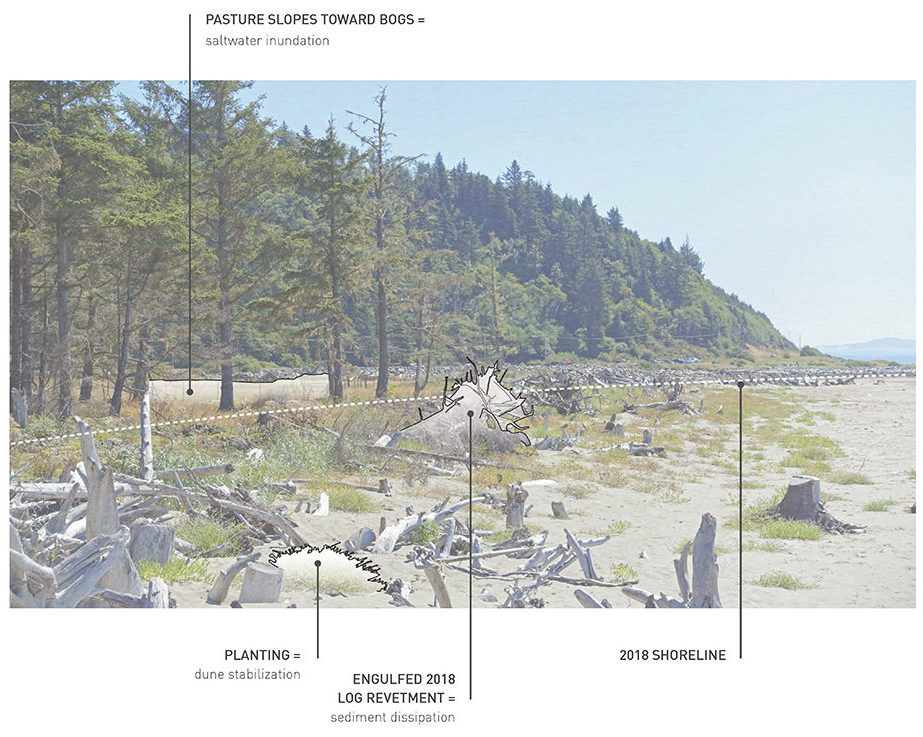
Numerous engineered logjams standing up to 8 feet above the beach—first installed in 2018, and then followed by plantings—have been covered with sand, creating a shallow beach slope. With beach erosion, this reach of beach could have allowed for saltwater to breach the dune and flow into the cranberry bog system.
Drainage Ditch #1 Siding
Drainage Ditch #1 is the only drainage system serving the southern cranberry bogs. Storm and wave systems gather from the south with a 30-mile stretch, pushing water and debris up the mouth of the ditch. With high-energy waves and currents, erosion increases. The higher the energy, the more logs capture sediment. The armature of engineered logjams, together with rock and cobble along the ditch and beach, capture sand to create a natural buffer for the drainage ditch.
Experimental Cultural Tools for a Living Shoreline: A Team Playing on Strengths in an Arena of Rapid Change
“The more we played, the more we understood it was important to understand the areas of instability and stability. If the area of instability seems to lack material, you bring material in there to absorb high energy and engage with the water as quickly as possible. The water shows you where the material needs to be.”
— Connie Allen and David Cottrell of Wash Away No More during an August 2020 site visit
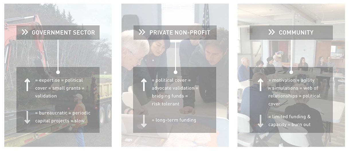
Similar to the experimental approach to physical tools used in beach building, the coalition formed to rapidly deploy and modify beach-building action plays into the strengths of each team member. The government sector brings expertise and small grants supporting experimentation; the NGO community provides local and regional support through grants with a greater risk tolerance; and the grassroots community brings the motivation and local capacity to steward the experiment with frequent efforts and onsite observation, resulting in a feedback loop fostering innovative testing. Each contributes to the collective, creating the ability for rapid action. This framework offers a model for other future actions when experimentation and immediate action are required and where innovation grows out of on-the-ground exploration.
Wash Away No More: A Grassroots Approach to Resilience
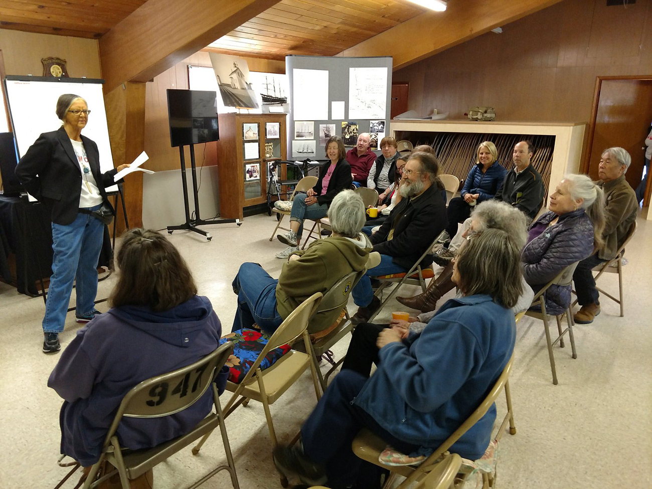
North Cove Remembrance event, 2018. Charlene Nelson, Chairwoman of the Shoalwater Bay Tribe, presents Wash Away No More to South Beach community members. These events ignited a grassroots movement against rising sea levels and the rapid erosion of Washaway Beach. Credit: Eirik Johnson
The Pacific Ocean is a powerhouse of energy. This is coupled with the reduction of sediment and logs feeding the beaches as part of a larger system of material transport along the coast. The Pacific Ocean and the annual erosion are not a small challenge to take on. The two-year-old Wash Away No More experiment is a fundamentally different approach to resilience, rethinking the relationship of humans to powerful systems. Following years of devastating coastal erosion, this approach shifts the relationship between the community and its environment from one of retreat to one of proactive experimentation, using a grassroots foundation supported by government and organizations. This is an optimistic strategy that offers a different way to view the situation and act. Positive experimental action changes the community and individual relationship to the history of erosion from victim to partner, using the power of waves to reestablish the beaches.
The increase in beach growth over just two years has been remarkable, sustained even through winter storms. The work has involved the constant feeding and modification of beach-building tools. As grant monies come to an end, the next steps should involve larger commitments to an experiment that has a track record of success and critical lessons learned.
With climate change and its impact on natural and human systems, experiments like Wash Away No More are relevant beyond North Cove. It provides a case study of close attention to natural systems, innovation, experimentation with a willingness to fail, and harnessing the combined capacity of a community and institutions. The approach offers an alternative lens through which to rapidly tackle critical issues, and could be scaled up for greater action.
◊
The author would like to thank the following individuals for their contributions to this piece: Connie Allen and David Cottrell, Wash Away No More; Michael Case, PhD, forest ecologist, The Nature Conservancy (Washington field office); Bernard T. Bormann, professor of forest ecosystems and director, Olympic National Resources Center, University of Washington; and John Shaw, executive director of the Westport South Beach Historical Society.
Biographies
Barbara Swift
is a landscape architect and urban planner who leads the Seattle-based Swift Company. Her work investigates the relationship between place and ecology, and has been acknowledged by multiple awards and fellowships with Centrum, the European Ceramic Work Centre, and the Runstad Center. Her commitment is evidenced in her years of service with the Seattle Design Commission, Seattle Arts Commission, and as editorial board member for Arcade Magazine.
The views expressed here are those of the authors only and do not reflect the position of The Architectural League of New York.