Brownsville, Texas
Brownsville West Rail Corridor Study: Designing Public Space in the 21st Century
In this report, we wanted to explore how residents can gain more control over their environment. Participatory design processes are more and more commonplace in the broader design world, but they can be easy to take for granted, as they have not been embraced everywhere. Jesse witnessed the work of urban planning expert Edna Ledesma as she led an academic design studio centered around community engagement in the design of public space. The following are her thoughts on participatory design within the context of a trail project. —Lizzie MacWillie, Kelsey Menzel, Jesse Miller, and Josué Ramirez, Brownsville Undercurrents editors
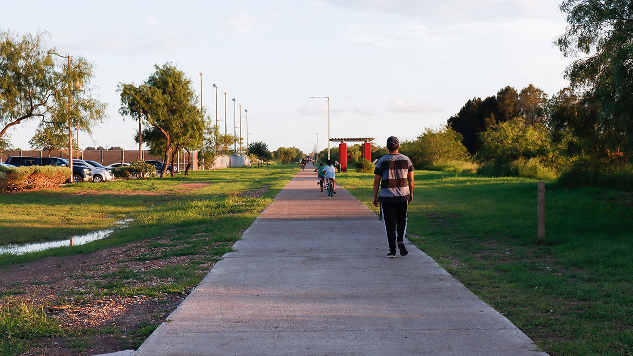
Brownsville residents walk and bike on the Paseo de la Resaca trail system. Credit: Veronica Gaona
The democratic vision of public space is one that offers choice: public space that all members of society can freely experience, where unplanned interactions can expand and enhance daily life. In Brownsville, Texas, my hometown, exclusionary design tactics such as the construction of the US–Mexico border wall through parks and the prioritization of resources for vehicular transit over active transit limit access to public space. These tactics ignore the needs of people.
The undemocratic nature of much public space today begins with design, and design school is where designers learn not to listen to everyday people. Bottom-up approaches to public space design, which are not typically taught in school, are needed to ensure communities are heard and understood, that their identities are reflected in places. Through my work on the West Rail Corridor, an eight-mile-long, 100-foot-wide right of way left over from a railroad that was abandoned in 2014, I had the opportunity to explore with students what a participatory and democratic approach to public space design would look like in Brownsville.
The West Rail Corridor is located on the southern edge of the city, running parallel to the Rio Grande and the US–Mexico Border Wall. It links both economically deprived and affluent neighborhoods directly to the historic downtown. Prior to its abandonment, the railroad crossed into Mexico, providing a potential international connection.
The plan to abandon the railroad was in the works for years. Originally, the Cameron County Regional Mobility Authority planned to replace the railroad with a toll road. This idea was widely opposed by local residents, who organized a successful campaign to permanently shelve the toll road proposal. In turn, the County, with lobbying from local developers, proposed a four-lane boulevard with a landscaped median. The residents also opposed this idea, advocating instead for a dedicated hike and bike path. This is where the city found itself in 2014: with a vacant corridor with competing visions and no clear consensus going forward.

West Rail Corridor Context Map. Credit: Edna Ledesma using Google Earth Aerial Photo, 2017
In 2017, I served as the Race and Gender Post-Doctoral Fellow at the University of Texas at Austin. I set out to remake the architecture design studio to teach students how to design with community members while radically imagining a new public space for Brownsville through the West Rail Corridor Study. The study was a research partnership between the University of Texas at Austin School of Architecture and Texas Southmost College (TSC), the local community college in Brownsville, which offers a two-year associate degree in architectural design. The core purpose of the research was to subvert traditional top-down approaches to public space design while exploring the significant beneficial impact that access to hike and bike infrastructure has for health, mobility, and community development.
Underwritten by a research grant from the City of Brownsville, the study created an interdisciplinary studio that moved beyond traditionally insular teaching and research techniques to incorporate public engagement and partnerships. The City’s decision to work with an academic design studio over a professional planning firm was adept. For years, professional planners prepared plans for the city, mostly using boilerplate community meetings. The resulting plans lacked the critical public collaboration and buy-in that can help ensure implementation. Contrary to this approach, in recent years the local TSC architecture program has been incorporating resident-engaged studio projects into its curriculum. These projects usually involved City departments, giving the municipality another view of how design and planning can be approached.
Within these contexts, participating students convened in Brownsville, representing the fields of planning, urban design, landscape architecture, and architecture at the graduate and undergraduate level. The students, hailing from Central Texas, the Rio Grande Valley, and Matamoros, Mexico, focused on potential redevelopment schemes for the corridor. Informed by a series of community input sessions that included community members, local developers, grassroots organizers, and city planning directors, the study explored comprehensive design visions that addressed human-oriented mobility, environmental protection, affordable infill housing, new social programming, and economic development.
We explored a more equitable approach to public space design, one that lies at the intersection of how public policy and design practices can combine to enhance the social and physical fabric of cities. We looked at the intersection of Latino studies, public health, environmental justice, infrastructure, and social movements.
One example of the impact of this approach was through the issue of vehicular access along the corridor, a key point of tension between developers and the grassroots organizers. The former saw vehicular access as the more profitable choice, while the latter feared automobiles would create an unsafe biking environment. Our proposals found a middle ground. A transit analysis showed that the surrounding roads were not used at capacity, eliminating the need to build another road for the entire length of the corridor. On the other hand, residents in the core of the city have less access to private vehicles and depend more on public transit. The integration of vehicular access for a bus-only lane along the eight mile-corridor would help increase transit access.
The design studio informed the City’s corridor redevelopment planning process, leading to an agreement between local stakeholders, the City, and the County that includes a continuous hike and bike trail for the entire corridor and incorporates a road for less than one mile.
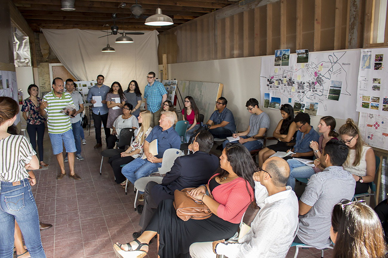
Students present preliminary analysis in Brownsville to community stakeholders. Credit: Edna Ledesma
While participatory design is becoming more common in design education around the country, it is not widely practiced or taught in Texas. Design silos are still very much a thing. The pedagogical shift we tested was centered on collaboration. This posed challenges for students that had limited-to-no experience with community engagement. The interdisciplinary component also pushed the students’ boundaries due to their lack of familiarity with the ways other disciplines approach problem solving. These challenges reinforced my understanding that architectural education must be at the center of work leading to the democratization of the design of cities and public space.
The West Rail Corridor study built off the City’s 2013 Hike and Bike Master Plan and supported the effort of the 2016 Cameron County Active Plan, a blueprint for a 428-mile hike, bike, and paddle trail network that will link natural, cultural, and historical resources to create a unified regional identity for outdoor tourism.1“The Active Plan of the Lower Rio Grande Valley.” Rails to Trail Conservancy. (2016). See source. It is estimated that 70 percent of the adult population in the Rio Grande Valley has at least one chronic health condition, many correlated to high rates of obesity. Studies have found that 58.4 percent of the adult population has had no physical activity for at least a week.2Reininger, Belinda M., and Lisa Mitchell-Bennett, MinJae Lee, Rose Z. Gowen, Cristina S. Barroso, Jennifer L. Gay, Mayra Vanessa Saldana. “Tu Salud, ¡Si Cuenta!: Exposure to a community-wide campaign and its associations with physical activity and fruit and vegetable consumption among individuals of Mexican descent.” Social Science & Medicine, Volume 143 (2015) : 98-106. See source. The Active Plan emphasizes how walkability and increased physical activity via recreation, such as cycling, can increase positive long-term health impacts. One study showed that having access to walking or jogging trails is associated with a higher percentage of people meeting current activity recommendations compared with those who don’t have access to trails. The same study found that every dollar spent on trails returned $2.94 in direct medical benefits.3“Impact: A Report of Rails-to-Trails-Conservancy’s Outcomes, Fiscal Year 2018.” Rail-to-Trails Conservancy. (2018). See source. Investment in Brownsville’s public space needs to do double or triple duty in its work. Improvement in health-improving mobility means not only multimodal access to places where people work, live, and play, but also long-term economic benefits as the community overcomes chronic health disparities.
The West Rail Corridor study is a case study for a community-centered approach to design which took the voices and concerns of local stakeholders into account. The process of integrating an educational studio into a real-world, active project allowed for a more authentic and pluralistic form of academic thinking. Bridging the discourse through partnerships at multiple levels and allowing students to serve as the connectors in that process reinforced work advancing equity through planning and design practice. Continuing this practice in the design of Brownsville’s public spaces will not only mean spaces that reflect the needs, desires, and identity of residents, but ones that address economic and health challenges as well.
Biographies
Edna Ledesma
is an assistant professor in the department of planning and landscape architecture at the University of Wisconsin-Madison and the co-director of the Kaufman Lab For the Study and Design of Food Systems and Marketplaces. She holds a PhD in urban and regional science from Texas A&M University, master’s degrees in architecture and urban design from the University of Texas at Austin, and a bachelor’s in environmental design from Texas A&M University. The corpus of her research, teaching, and mentoring focuses on understanding the development of the smart, green, and just twenty-first-century city, in particular the cultural landscapes of immigrant populations, micro-economies, and how they contribute to a new understanding of city place.
The views expressed here are those of the authors only and do not reflect the position of The Architectural League of New York.