March 1, 1993
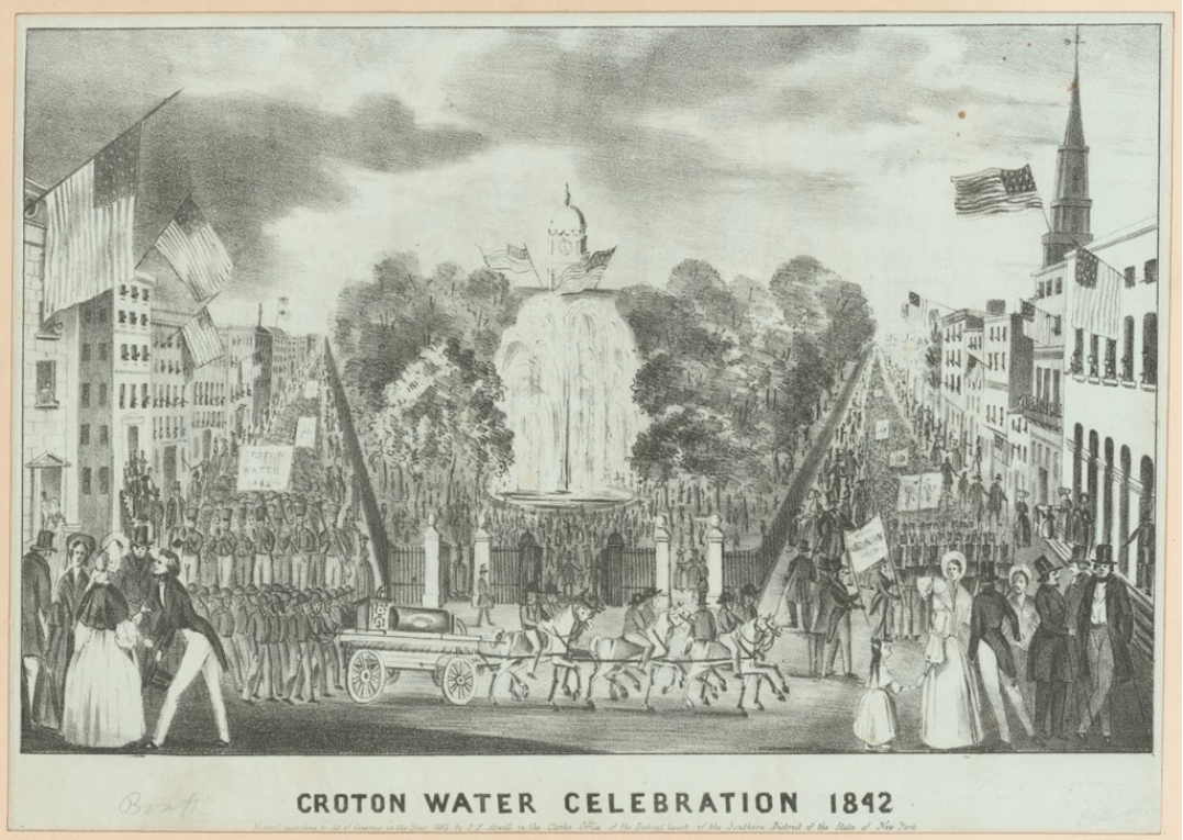
Croton Water Celebration, 1842. Courtesy of New York Public Library
In 1992, the League partnered with the New York City Department of Environmental Protection and the Parks Council (now New Yorkers for Parks) to organize a design study titled The Productive Park that explored how parks and neighborhood amenities could be coupled with the city’s infrastructure, and how design could contribute to public works.
Concurrent with the open call for participation in the design study, the League organized an exhibition on the history of New York City’s water supply that surveyed the history of the waterworks, with particular attention to the buildings constructed as part of the system and to the many parks whose existence and form are inextricably connected to it. This essay, “Waterworks: Architecture and Landscape,” authored by Thomas Cirillo, Rosalie Genevro, and Anne Rieselbach, was written for an unpublished catalogue for that exhibit.
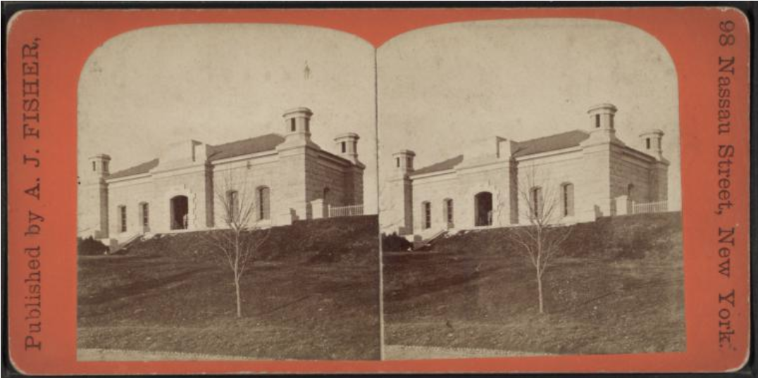
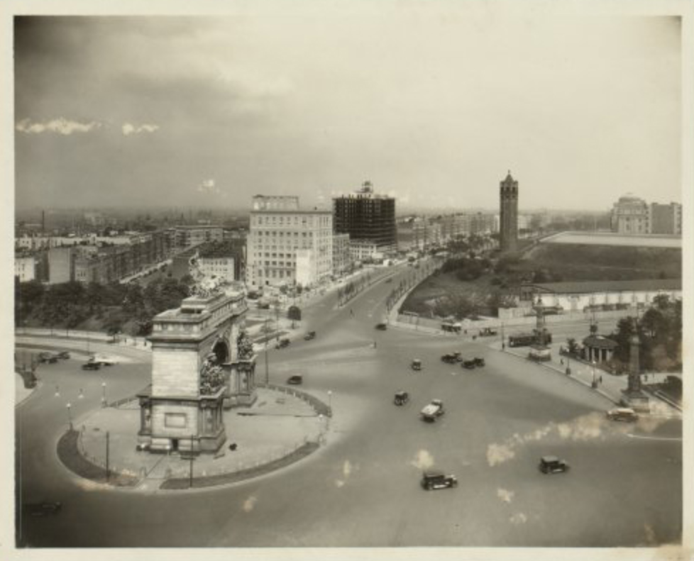
With little or no direct visual experience of the sources and workings of the water supply, current-day New Yorkers most often think of it as totally automatic and totally underground. But the earliest parts of New York’s supply network—the Old and New Croton Aqueducts and the groundwater system that supplied Brooklyn—produced remarkable manifestations above ground in the city itself. The water towers at Highbridge, 98th Street, and Mt. Prospect, the reservoirs at Central Park, Murray Hill, and Ridgewood, and numerous gatehouses and pumping stations all testified to the same sense of civic ambition and design quality shown in the engineering of the dams, pumps, and pipes that made the system work. Important parks such as Bryant, Jerome, Highbridge, and Highland, and significant features in others such as Union Square and Central Park, were direct outgrowths of the building of the water supply network.
New York’s water supply is the most crucial of the several magnificent systems of civil engineering that make the metropolis possible, and it is the most closely tied to the natural systems of the region. The political and engineering vision and design skill with which the water supply system was created should be a source of enormous pride to New Yorkers. These earlier accomplishments can also serve as example and spur, to encourage us to use the opportunity of further development of the system to improve and embellish our city.
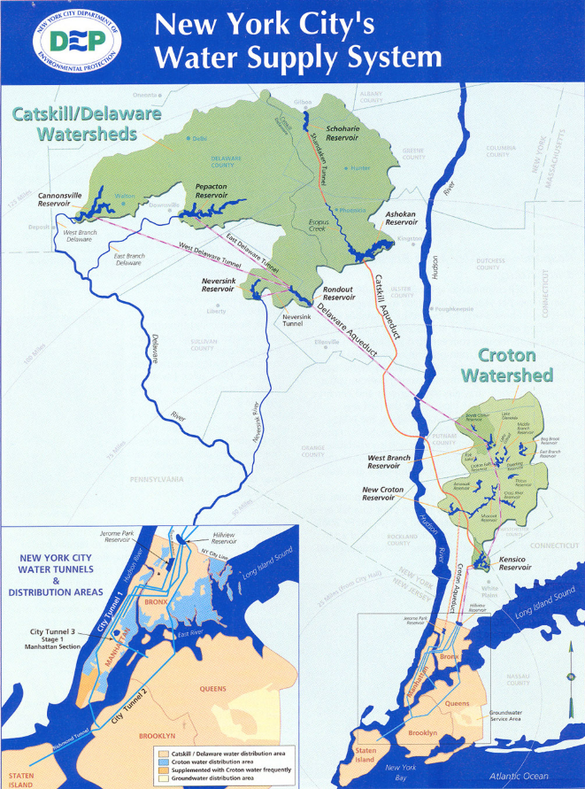
Map of New York City’s Water Supply System | Courtesy of New York State Department of Environmental Conservation
The Croton system
Nothing is talked of or thought of in New York but Croton Water; fountains, aqueducts, hydrants, and hose attract our attention and impede our progress through the streets. Political spouting has given place to water spouts.
—Diary of Philip Hone, vol. II, entry for October 12, 1842
On October 14, 1842, a grand celebration marked the opening of New York City’s first public water supply, the Croton Aqueduct. Thousands of spectators cheered a large parade which terminated at City Hall Park, where celebrants gathered to hear the governor and mayor address the crowd. An ode to the water supply was sung as a new fountain sprayed Croton water in changing formations up to fifty feet in the air.
The building of the Croton Aqueduct was the culmination of almost seventy years of attempts to locate sources and plan distribution of water for the city. Prior to the construction of the aqueduct, Manhattanites relied on wells, water merchants, and inefficient water companies. The city’s two main sources during the Revolutionary era were the Collect Pond and the Tea Water Pump. By 1798 the 48-acre Collect Pond was described as “stagnating” and “filthy,” and as this and other sources declined in quality, water from the Tea Water Pump was sold by merchants from mobile tanks.
Before the Revolutionary War, the City briefly had a waterworks, built and run by Christopher Colles. Colles’s system drew water from a series of wells and the Collect Pond. Despite decades of surveys for new water sources beyond the city’s boundaries, the next system—the Manhattan Company—simply elaborated on Colles’s arrangements. The Manhattan Company was incorporated in 1799 to provide the City’s water. The company’s charter included a clause allowing it to form a bank, and while the bank (the forerunner of today’s Chase Bank) prospered, the company’s efforts at supplying the city’s water were less than innovative or energetic. Rather than seek new sources outside the city, the company drew water from a well at Reade and Centre Streets and stored it in a reservoir on Chambers Street. Dissatisfaction with the quality and volume of the Manhattan Company’s service spurred a continued search for water for the city’s needs.
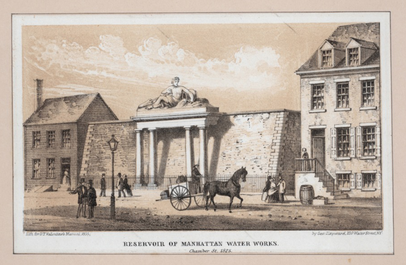
Chambers Street Reservoir, 1825 | Courtesy of New York Public Library
In 1829 the Common Council approved the construction of a City reservoir as a stopgap for fire control purposes. Supplied by well water pumped by a steam engine, the hexagonal structure was located at Broadway between 13th and 14th streets. A system of water mains carried the supply to surrounding areas and downtown.
A cholera epidemic in 1832 prompted the Common Council Committee on Fire and Water to hire Colonel DeWitt Clinton to make a study of possible new sources of supply. Clinton recommended use of the Croton River north of the city. Planning for the Croton system began with the hiring in 1833 of Major D.B. Douglas as Chief Engineer to outline a plan for construction. The Common Council and a subsequent popular vote in early 1835 formally approved the inauguration of work on the Croton system. Major Douglas was replaced by J.B. Jervis, a railroad and canal engineer, in 1836.
The aqueduct—about 40 miles long from the Croton Dam in Westchester to the distributing reservoir at 42nd Street—was a gravity-fed masonry conduit carried on embankments and through tunnels. It had a discharging capacity of 72,000,000 gallons of water per day. Special circumstances called for singular structures, such as the lofty arch over Sing Sing Kill, the monumental High Bridge over the Harlem River, with its design modeled on Roman precedents, and a long raised section of the aqueduct over Clendenning Valley in what later became known as the Upper West Side. The most prominent structures of the new system in Manhattan were the receiving reservoir in Yorkville, on land that would soon become part of Central Park, and the distributing reservoir in Murray Hill, where the Public Library now stands.
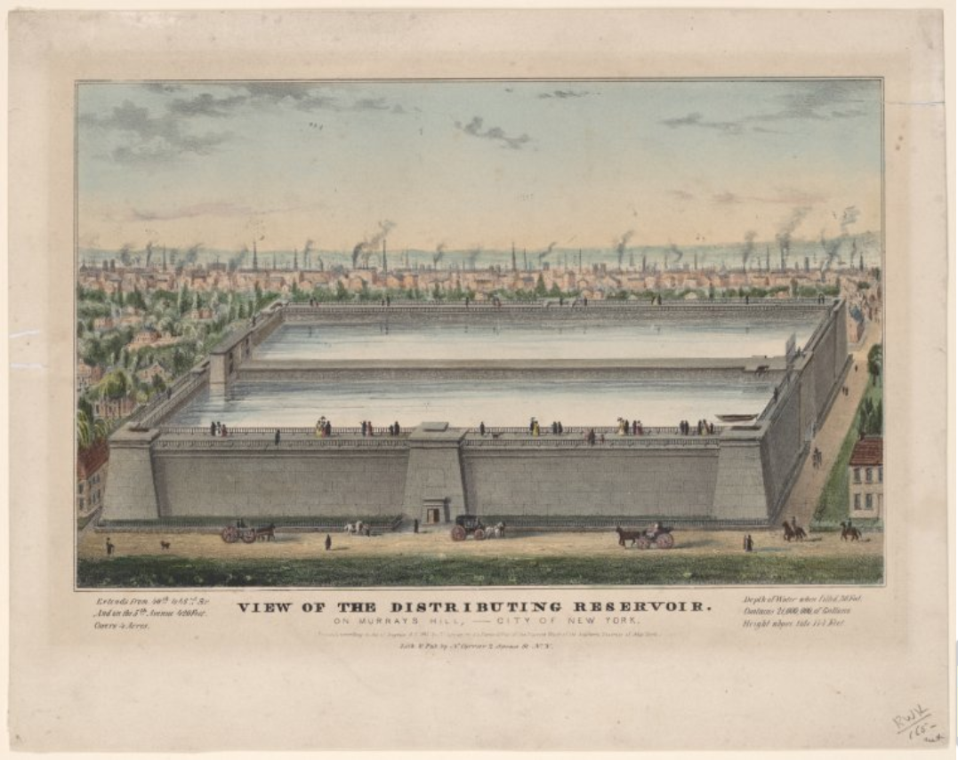
The Murray Hill Reservoir, which was about 430 feet square, had a holding capacity of 24 million gallons within its monumental battered walls. When the reservoir was built, the surrounding area was fairly rural, but was soon transformed by the rapidly developing city. The reservoir became a popular point for excursions, as walkways on top afforded views of New York’s growth. Shortly after mid-century, the Crystal Palace briefly filled the vacant land on the Sixth Avenue side of the reservoir. By the 1870s this site was occupied by Reservoir Square—today’s Bryant Park.
The receiving reservoir, located between 79th and 86th Streets in what would later become Central Park, was a rectangular structure 1,826 feet long and 836 feet wide with a holding capacity of 180 million gallons. Plans for a second, larger receiving reservoir began less than a decade after the opening of the Croton system.

Construction of the South Gate House, Central Park, 1862. Courtesy of New York Public Library
An initial rectangular design for the new reservoir, to be located between 86th and 95th streets, was supplanted by a more freeform shape harmonizing with the rest of the plan for the newly created Central Park. Working with the Park commissioners under the direction of Anton Viele (the engineer of Central Park prior to the tenure of Olmsted and Vaux), the Croton Aqueduct Department redesigned the reservoir to conform with the contours of the landscape, creating what became known as “Lake Manhattan.” The revised design also saved about $200,000 by avoiding heavy rock cuts and embankments. The new reservoir, completed in the summer of 1862, had a water area of 96 acres, and a holding capacity of 1 billion gallons.
Central Park North Reservoir. Courtesy of New York Public Library
As early as 1850, demand much higher than anticipated required that the city look toward increasing the amount of water held in watershed reservoirs as well as increasing the volume of water that could be transported to the city. Initially this was in part accomplished by filling the conduit 32″ higher than planned, which increased its capacity to 95 million gallons per day. In addition, engineers studied the means of providing adequate water pressure to taller buildings and higher-lying areas of the city.
A reservoir at Williamsbridge fed by water taken from the Bronx and Byram Rivers was completed in 1884. A number of new reservoirs were completed in the Croton watershed, including those at Boyd’s Corners, Middle Branch, and Amawalk. High pressure service came to Manhattan with the construction of the High Bridge Tower and Reservoir between 1870–72, and a tower on West 98th Street completed in 1879.
The most important construction during these years was of the new Croton Aqueduct, providing a second, higher volume source of water for the city. Unlike the Old Croton Aqueduct with its embankments and bridges, the New Croton Aqueduct was carried completely underground. Completed in 1891, the aqueduct ran through a brick conduit to a new reservoir at Jerome Park, and then through a pressure tunnel to the 135th Street Gatehouse in Manhattan and on to the receiving reservoir at Central Park. Rather than crossing the Harlem River by bridge, the new aqueduct funneled through an inverted siphon under the river.
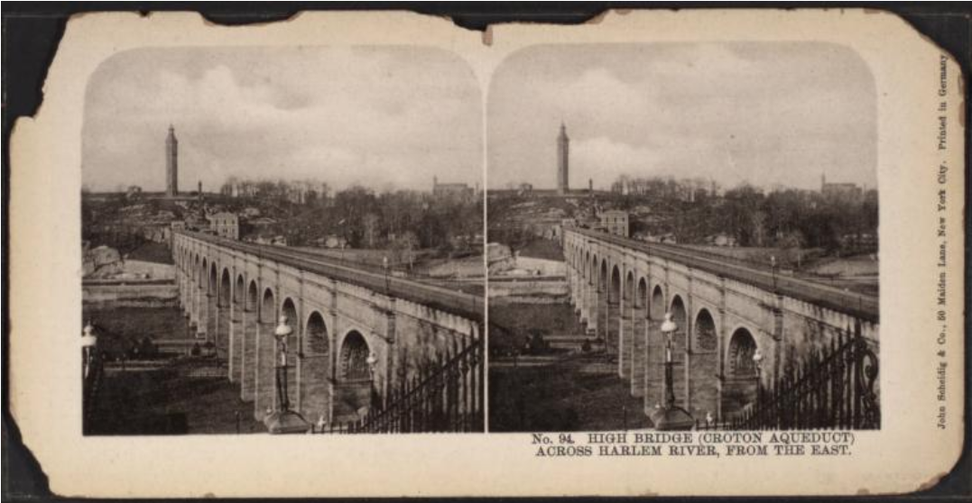
High Bridge across the Harlem River, 1900. Courtesy of New York Public Library
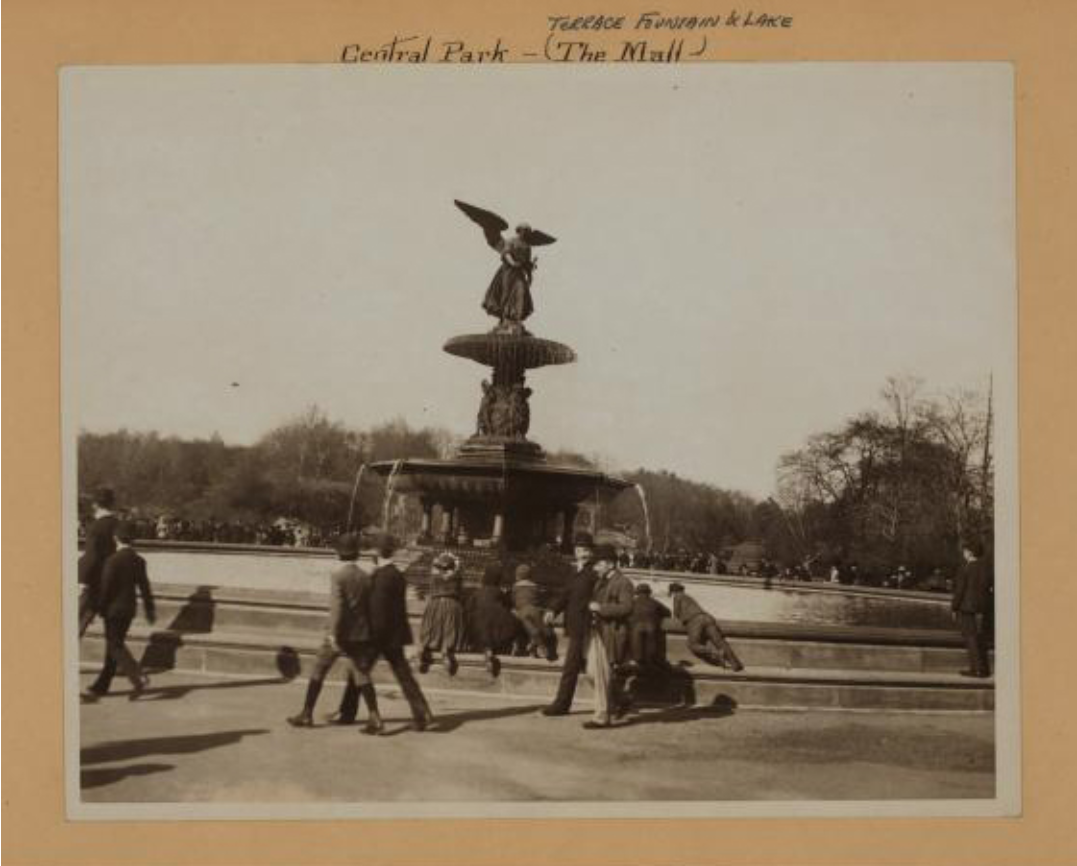
A number of structures linked to the first and second Croton aqueducts still stand today, in the watershed areas as well as in New York City. The Central Park and 135th Street gatehouses, with their expressive Italianate architecture, and High Bridge aqueduct and tower are some of the more notable examples. Emma Stebbin’s sculpture of Angel of the Waters, which is the centerpiece of Central Park’s Bethesda Fountain, in part celebrates the pure water supply made possible by the construction of the aqueduct and reservoir. Although the first reservoir was tilled, the second reservoir still occupies a significant portion of the park.
Angel of the Waters statue in Central Park, 1892. Photo by Ewing Galloway, courtesy of New York Public Library
Reservoir Square, renamed Bryant Park and redesigned a number of times over the years, provides a midtown oasis. It no longer shares a site with the Murray Hill Reservoir, which became superfluous to the system. Despite various plans advanced for the site, including a hanging garden set in and above the reservoir, the structure was demolished in 1899. The main research branch of the New York Public Library opened on the site in 1911.

Croton Reservoir, looking south along Fifth Avenue, 1879 (demolished 1899). Courtesy of New York Public Library
The Brooklyn water supply
Brooklyn, like Manhattan, relied on private wells and pumps as its primary source of water through the first part of the nineteenth century. After Brooklyn incorporated in 1834, a series of commissions was appointed to recommend how the city should acquire a water supply for the future. Because of its location and geology, Brooklyn had a choice among several methods of obtaining its supply. Long Island—of which Brooklyn forms the western end— was created by the deposits of glacial movement during the last Ice Age. The glaciers caused the creation of underground layers of waterbearing sand and gravel, or aquifers. Debate about a water supply for Brooklyn was complicated, however, by an inadequate understanding of this geology and the sources at hand. Several plans for Brooklyn, incorporating both ground and surface water, were considered: one called for the development of wells and cisterns at Fort Greene Hill (in the area that became Washington Park, now known as Fort Greene Park); others proposed tapping Long Island’s various streams and ponds in combination with well fields. As early as 1847 some sort of connection to New York’s Croton system was suggested.
During the decade from 1840 to 1850 the population of Brooklyn more than doubled—from under 37,000 to over 96,000—making the need for increased water supply increasingly important. But despite the devastating fire of 1848, the Brooklyn Common Council remained unable to set the city on a course which would guarantee an adequate water supply for the future. After some twenty years of discussion, a plan for a municipal water works was presented in 1853 but rejected in a public referendum: a revised plan, presented later that year, met the same fate.
As debate continued at the city level, the private Williamsburg Water Works Company was formed in 1852. With a plan to take water from wells within the city limits and from the streams and ponds of southern Long Island, the company made a formal offer to provide the city with water, changing its name first to the Long Island Water Works Company and later to the Brooklyn Water Company. By 1853 it had acquired several ponds, including Smith’s (Hempstead), Baiseley’s, Valley Stream, and Cypress Hills (Ridgewood).
Brooklyn annexed the towns of Williamsburg and Bushwick in 1854, dramatically increasing the city’s population, and bringing the need for a more active municipal role in water acquisition to the forefront. In 1855 the Common Council chartered the Nassau Water Company and incorporated it as the first large scale engineering attempt to provide for a future demand estimated at 20 million gallons per day. The following year, the Common Council subscribed $1.3 million to the stock of the Nassau Water Company, with the option to buy back the entire system at cost. In June of 1856, James P. Kirkwood was selected as the chief engineer of the ambitious system. The Nassau Water Company was given the right to purchase all the property of the Brooklyn Water Company, divert any stream or pond necessary to procure more water, and lay pipes throughout the city. The Common Council stipulated, however, that rates could never exceed the New York City rates for Croton water.
Work on the new system was inaugurated with a celebration at the site of the future Ridgewood Reservoir on July 31, 1856. During the next year, while the system was under construction, the City of Brooklyn bought out the Nassau Water Company. On November 18, 1858, water was first pumped into Ridgewood Reservoir; in December water from distributing mains was first used in the city to extinguish fires. On April 28, 1859, a public ceremony celebrating the completion of the system’s main features was attended by over 300,000 Brooklynites. That same year a permanent Board of Water Commissioners was formed to control the Nassau Water Company.
The west watershed and its expansion
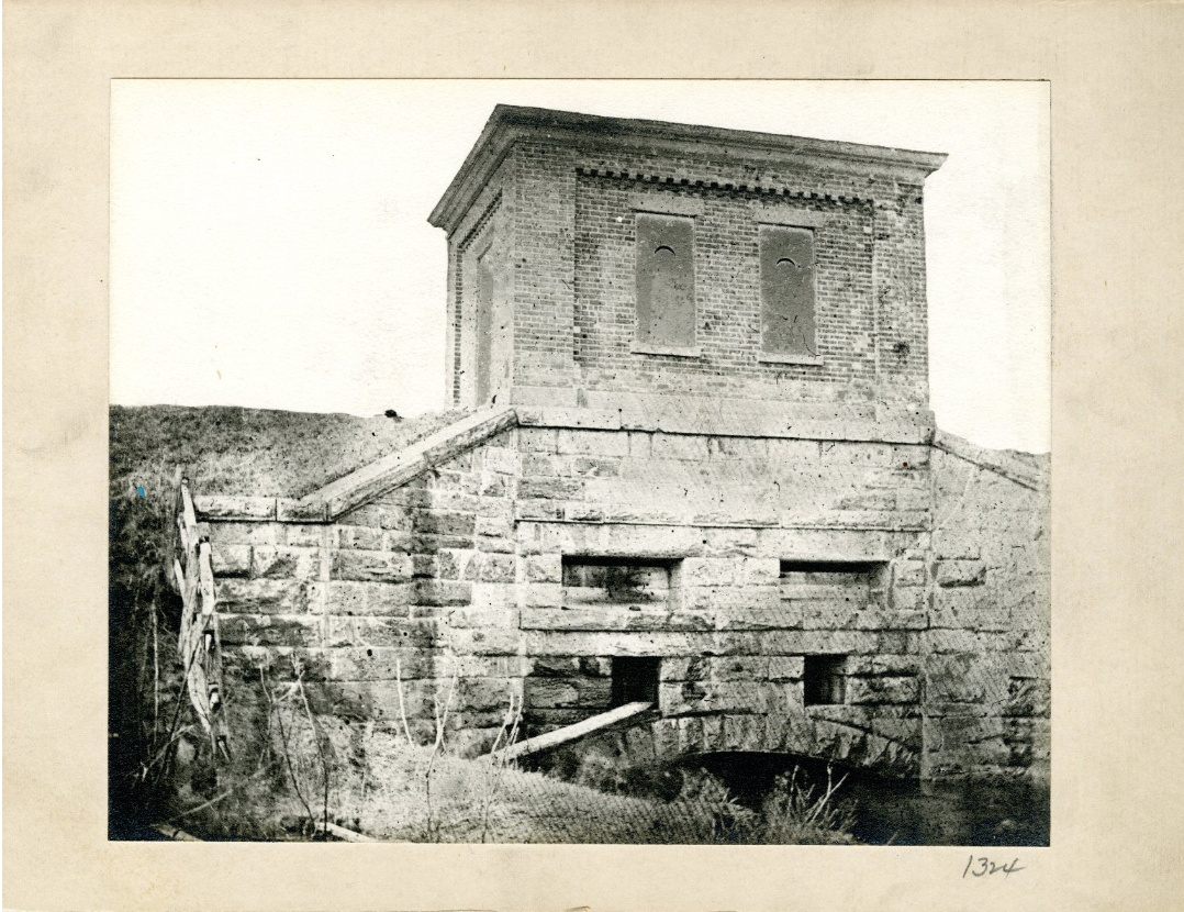
The original Ridgewood water works were completed in 1862 and provided a minimum daily supply of 20 million gallons derived from Jamaica Stream (Baiseley’s Pond), Simonson’s Stream, Clear Stream, Valley Stream, Pine’s Stream, and Hempstead Stream. Water was brought into the city through a twelve mile long masonry conduit to Ridgewood pumping station, at the present-day intersection of Atlantic Avenue and Logan Street in East New York. Along the line of the conduit, supply pond gate houses were constructed to release water from the ponds into the aqueduct; culvert gate houses diverted the flow directly from streams. When the water reached the Ridgewood Pumping Station, it was pumped through force mains into Ridgewood Reservoir, the main distributing reservoir for the city of Brooklyn. Another reservoir and pumping station on Mt. Prospect, the highest point in the city, served the elevated areas around Grand Army Plaza. The quality of the water provided by the Ridgewood system was said to be as good as the water provided by New York’s Croton system.

Ridgewood Reservoir, Brooklyn, ca. 1872-1887. Credit: George Bradford Brainerd, courtesy of the Brooklyn Museum
By 1871 this supply was wholly absorbed by the city’s rapidly growing population and throughout the 1870s the threat of a water famine was a growing concern. In 1872 temporary stations were established at Watt’s Pond and Smith’s Pond and work was begun on a one billion gallon storage reservoir at Hempstead to increase daily supply to thirty million gallons. An extension of the entire works eastward beyond Hempstead had been advocated since 1877, but work on this, including a new reservoir and pumping station at Millburn, was not contracted until 1889. In the meantime, the capacity of the existing system was augmented by the addition of various ground water sources, drawing from the easily accessible Upper Glacial aquifer. Five million gallons per day were added with the inclusion of well stations at Springfield and Watt’s Ponds and over twenty million gallons with the construction of driven well stations at Spring Creek, Baiseley’s, Forest Stream, Clear Stream, and Jameco. By 1890 the capacity of the original Ridgewood system, with the considerable addition of ground water sources, had been increased to about 57 million gallons per day.
The east watershed and other sources
Much of the debate that delayed authorization of the eastern extension was about whether to institute metering to control consumption. Fearful of the political repercussions, the city commissioners decided against metering private consumers and committed the city to a large-scale expansion of the system. The eastern extension, completed in 1892 by chief engineer I.M. de Varona, drew primarily from the streams at Millburn, East Meadow, Newbridge, Wantagh, and Massapequa and supplied Brooklyn with an additional 25 million gallons per day. Water collected from sources on the eastern watershed was carried by a new seven-mile extension of the brick conduit to the Millburn pumping station, where it was in turn sent through 48-inch cast-iron mains to Ridgewood for use in the city.
As part of the expansion, a new pumping station was built at Ridgewood and the capacity of the storage reservoir there was increased by 150 million gallons. Construction was begun on the stand pipe and water tower at Mt. Prospect to provide increased water pressure to customers in the highest areas of the city. The Mt. Prospect Tower, designed by Thayer and Wallace, was completed in 1893.
Because of population growth and the long delay in authorizing the system, consumption soon equaled supply once again and additional provisions for the city’s requirements were necessary. As had taken place with the original Ridgewood system, the capacity of the new eastern watershed had to be gradually expanded to meet the city’s growing demand. To this end, new investigations focused on the possibility of developing a supply from deeper wells which would draw water from the lower-lying aquifers. Around 1895, the Department of City Works developed a series of deep artesian wells at the Jameco site, drawing water from the aquifer at a depth of about 150 feet and adding five million gallons to the available daily supply. Though the magnitude of this addition was not very significant, city officials recognized the viability of tapping Long Island’s vast underground reservoirs as a supplemental resource at a modest cost. A bid was soon made by a private contractor to provide Brooklyn with an additional supply of ten to 30 million gallons from deep well sources with no effect on existing sources.

Map of the Borough of Queens, including the Ridgewood Reservoir, in G.W. Bromley & Co.’s 1909 Atlas. Courtesy of New York Public Library
Increased demand was also met by several private water companies that began supplying Brooklyn residents during the last decades of the century. The Long Island Water Supply Company built its works in 1881 on New Lots Avenue at the head of Fresh Creek. The New Utrecht Water Company, at East 14th Street and Avenue E, and the Gravesend Water Works, at 17th Street between Avenues R and S, supplied groundwater during the same period and were acquired by the City of Brooklyn in 1895. The Blythebourne and the West Brooklyn Water Works, outside the city limits, also supplied some households in the 30th Ward of Brooklyn until they were absorbed by the city early in the twentieth century. The Flatbush Water Company built its works in 1882 at the intersection of York Avenue and Avenue E and continued to provide groundwater to the residents of that neighborhood until 1947, when it was closed by the city. This event marked the end of an era and the disappearance of “Flatbush Punch” was celebrated by some, but mourned by many Brooklynites.
In the years directly preceding the 1898 consolidation of Brooklyn and New York City, Brooklyn commissioned preliminary studies on the possibilities for procuring an additional water supply of 100 million gallons per day. This investigation, however, was tempered with the knowledge that a merging of the two cities would dramatically change the factors pertinent to such a decision. In a detailed report published in 1896, two watersheds were considered on the mainland—the Ten Mile River, just north of the Croton watershed; and the Ramapo watershed, west of the Hudson River—as well as the large-scale development of the Long Island watershed east into Suffolk County. The future water supply of the combined cities was thus one of the most important considerations when Brooklyn finally consolidated with New York. The subsequent search for an additional water supply included the sources Brooklyn had explored, along with the Housatonic River, the Delaware River at Port Jervis, and the Catskill watershed, which was ultimately developed.
The Catskill Aqueduct Headworks, 1913. Courtesy of New York Public Library
By necessity, the Brooklyn system continued its gradual expansion in the years preceding 1917, when Catskill water was first delivered to the Long Island boroughs of Queens and Brooklyn. From 1903 to 1906, infiltration galleries—perforated clay pipes laid underground—were built at Wantagh and Massapequa to collect groundwater from the Upper Glacial aquifer. Traditional well fields were also constructed at these and other sites in Nassau County and in 1908 a new 72-inch steel force main was built to deliver a high pressure water supply from the Nassau–Suffolk county line into the city. By 1916, Brooklyn had an average daily water supply of 127 million gallons: 73 million gallons from wells ranging in depth from 30 to several hundred feet, 34 million gallons from infiltration galleries, and 20 million gallons from surface water supplies.
The Ridgewood system was not completely abandoned upon completion of the Catskill system in 1917. The New York City Bureau of Water Supply maintained the system and used it as a secondary source through the 1950s. The Ridgewood system was used for the last time during the drought of 1966, after which it was mothballed because of deteriorating quality and the plentiful supply created by the completion of the Delaware system. The Watt’s Pond well field has since been convened into a park and the field at Jameco, immediately below Baiseley’s Pond, is now the site of Baiseley’s Pond Park. In 1986 most of the remaining facilities were sold to Nassau County.
The Catskill system

Catskill Aqueduct Headworks, 1913. Courtesy of New York Public Library
On October 12th, 13th, and 14th, 1917, 75 years exactly after the great Croton festivities, New York City celebrated another extraordinary accomplishment: the completion of the first stage of the Catskill system. The mayor had appointed a committee of five hundred citizens to plan the celebration, which included an exhibition on the history of New York’s water supply at the Public Library, a jet of Catskill water at the Central Park gatehouse, and an allegorical pageant in the Sheep’s Meadow.
Development of the Catskill system was guided by the Board of Water Supply, a powerful agency whose creation was authorized by the Legislature in 1905. In 1899, New York had narrowly escaped contracting to have a private group, the Ramapo Water Company, build a new system and supply water to the city for the next forty years, under terms quite unfavorable to the city. A series of investigations followed, culminating in the creation of the Board of Water Supply, which had extensive powers to plan for a new system and acquire the property necessary to build it.
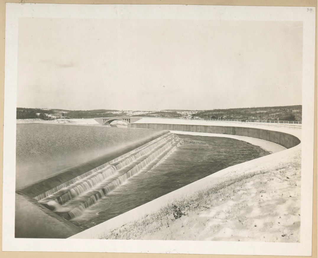
Ashokan Reservoir Spillway, leading to Esopus Creek, 1916. Courtesy of New York Public Library
Construction of the Catskill system began in 1907, under the direction of Chief Engineer J. Waldo Smith. The first stage consisted of the building of the Ashokan, Kensico, Hill View, and Silver Lake Reservoirs, the aqueduct itself, and City Tunnel No. 1. Ashokan Reservoir was built in a rural but populated area of the state, and required the relocation of 2,000 residents, the relocation of railroads and highways, and the removal and reinternment of almost 3,000 bodies from cemeteries. The 8,180-acre reservoir is fed by Esopus Creek and diverted water from the Schoharie watershed. Water travels 92 miles through the aqueduct from Ashokan to the holding reservoir at Kensico and thence to the distributing reservoir at Hill View. Hill View’s elevation, 293 feet above sea level, provides the gravity force necessary to deliver the water to the city at considerably higher pressure than the Croton system. Catskill water was first delivered to the Bronx in late 1915, to Manhattan in late 1916, and to Brooklyn, Queens, and Staten Island several months later.
Hill View Reservoir under construction, showing the sluice-gates for controlling the flow of water to the downtake shaft. Courtesy of New York Public Library
The magnificent Kensico Dam, in Westchester County, was built out of almost one million cubic yards of masonry and is 307 feet high at its highest point. Kensico Reservoir receives water from the Catskill and Delaware systems, as well as a much lesser amount from the Bronx and Byram River watersheds. Kensico serves as a storage reservoir, and was built to hold enough water to permit the aqueduct from Ashokan to Kensico to be closed and checked or repaired if necessary.
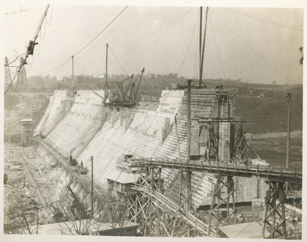
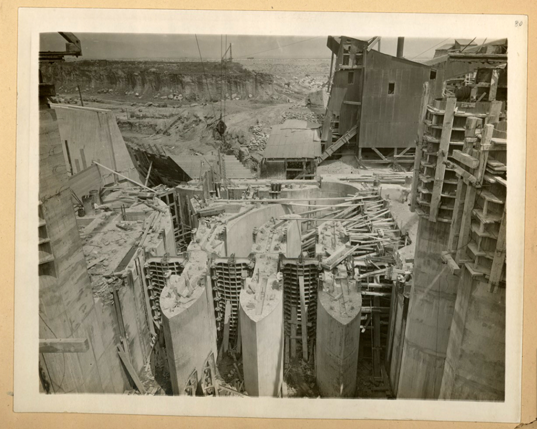
Kensico Reservoir, dam under construction, 1914 | Courtesy of New York Public Library
Two gate chambers at Kensico, one for Catskill water and one for Delaware, control the amount of water that moves to Hill View Reservoir. Before leaving Kensico, the water is chlorinated and forced through nozzles and into aeration basins to remove any gases which would affect its taste or quality. Water leaving Hill View Reservoir is delivered to New York through Water Tunnel No. 1, completed as part of the first stage of Catskill construction, and Water Tunnel No. 2, which was built during the early stages of the Delaware project. The 18-mile long Tunnel No. 1 travels under the West Bronx and Manhattan and terminates under Fort Greene Park in Brooklyn. Tunnel No. 2, twenty miles long, runs under the East Bronx, Rikers Island, Queens, and Brooklyn. The tunnels are between 200 and 740 feet below street level.
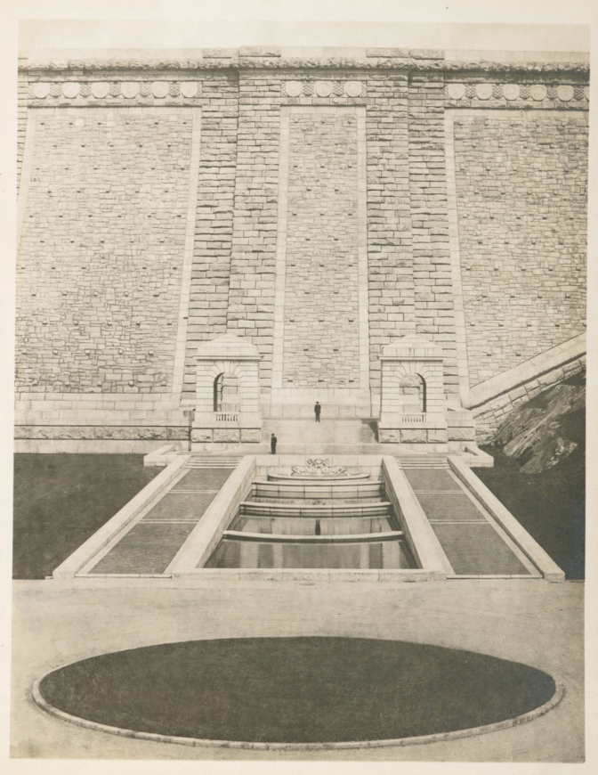
Kensico Reservoir, fountain and cascade basin, 1917. Courtesy of New York Public Library
Silver Lake Reservoir on Staten Island, built during the first stage of the Catskill project, is now the southern terminus of both the Catskill and Delaware systems. The reservoir was created by building artificial embankments to hold the water in a natural depression. The two-basin reservoir, which is 228 feet above sea level and holds almost 440 million gallons, serves as the distributing reservoir for the borough of Richmond. In contrast to the purely gravity-fed nature of most of the system, water from Silver Lake must be pumped to distribute it to higher-lying areas of Staten Island.
The second stage of construction on the Catskill system was already underway as the first stage was completed. Second stage work included the building of the Gilboa Dam to create the Schoharie Reservoir and the Shandaken Tunnel, which discharges Schoharie water in Esopus Creek, from which it flows into Ashokan Reservoir. This stage of the Catskill system was completed July 1, 1927.
The Delaware system
Although actual construction of the Delaware System was delayed some fourteen years because of legal action, depression, and war, its conception by the Board of Water Supply was visionary. Rather than react to a situation of shortage, the City planned a system that would meet its projected needs until the year 2000.
The Delaware project was approved by the Board of Estimate on January 12, 1928. Only in June, 1936, however, when the Board appropriated $17.5 million, did preliminary work and shaft construction actually begin. A significant source of delay was the interstate controversy about rights to the waters of the Delaware River, the headwaters of which lie in New York State. Soon after the project’s approval, New Jersey sued for an injunction in the United States Supreme Court. The “Delaware Decree” of 1931 gave New York City the right to divert up to 440 million gallons a day. In order to protect the water supplies of Philadelphia, Camden, and other downstream cities, New York was also required to build a sewage treatment plant on the Delaware at Port Jervis and to maintain a specified level of flow in the Delaware.
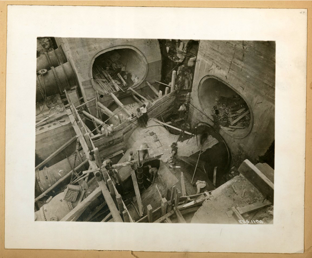
Construction of the Roundout West Branch Tunnel, part of the Delaware Aqueduct, in 1942. Courtesy of the New York City Department of Environmental Protection Archives
The Delaware system was designed for development in three stages: first, the construction of reservoirs at Rondout Creek and the Neversink River and the building of the formidable Delaware Aqueduct; second, the construction of Pepacton Reservoir and the East Delaware Tunnel; and third, the construction of Cannonsville Reservoir and the West Delaware Tunnel. All the Delaware system dams are constructed of rolled-fill earth embankments; they range from 1,500 to 2,820 feet long and from 175 to 204 feet high. The reservoirs thus created range in capacity from 35 billion gallons to 140 billion gallons.
The aqueducts of the Delaware system are exclusively deep rock pressure tunnels. Completed in 1944, the main aqueduct which connects Rondout Reservoir with the city is 85 miles long, ranges in diameter from 13 1/2 feet to 19 1/2 feet and lies between 300 and 1,000 feet below the general surface of the ground. It runs 2,500 feet below the crest of the Shawangunk Mountain range, 600 feet below sea level under the Hudson River and 1,000 feet below Kensico Reservoir. In 1955, the East Delaware branch (25 miles long) connecting Pepacton to Rondout was brought in service and in 1964, the West Delaware branch connecting Cannonsville to Rondout (44 miles long) came into use. In total, the Delaware system consists of some 160 miles of underground tunnel and aqueduct and provides about fifty percent of New York City’s daily water supply.
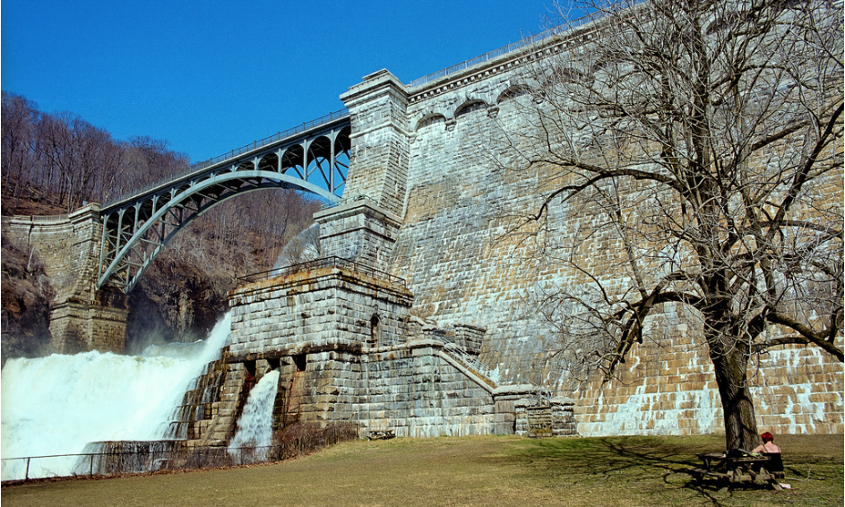
Croton Dam in 2010. Photo by George Bremer
Select Bibliography
American Water Works Association. The Water-Works of New York with instructions on how to reach them and other information. (Compiled for the convenience of members and guests at the 36th annual convention of the American Water-Works Association.) New York, 1916.
Citizens Union Foundation. Thirsty City: A Plan of Action for the New York City Water Supply. Robert Alpern, Project Director. New York, 1986.
Citizens Union Foundation. Water-Watchers: A Citizens Guide to New York City Water Supply. Robert Alpern, Project Director. New York, 1987.
Clark, Charles M., “Development of the Catskill Supply” and “History of the Delaware Supply,” Water Works Engineering (October 21, 1942).
“The Croton Aqueduct,” The New York Herald (October 14, 1842).
de Varona, I.M. Brooklyn Water Supply. Office of Engineer of Water Supply, Brooklyn Borough, 1896.
Hall, Edward Hagaman. The Catskill Aqueduct and Earlier Water Supplies of the City of New York. NY: The Mayor’s Catskill Aqueduct Celebration Committee, 1917.
Hochlerner, T. “Distribution System for New York.” Water Works Engineering (October 21, 1942): 1262-1267.
Johnston, Ken. “Croton Highballs Lack Zinginess of ‘Flatbush Punch.’” The Brooklyn Eagle (May 25, 1952, Flatbush Section).
Kirkwood, J.P. and the Board of Water Commissioners. The Brooklyn Water Works and Sewers: a Descriptive Memoir. New York: D. Van Nostrand, 1867.
Lankton, Larry D. “Valley Crossings on the Old Croton Aqueduct.” IA, The Journal of the Society for Industrial Archeology, vol. 4, no. 1 (1978): 27-42.
New York City Board of Water Supply, 1,820,000,000 Gallons per Day; 50th Anniversary of the Board of Water Supply. New York, 1955.
New York City Department of Water Supply and Electricity. The Municipal Water Supply of the City of New York, A General Description. New York, 1920.
Quilty, Patrick. “Croton Supply is 100 Years Old,” Water Works Engineering (October 21, 1942): 12.
Thurber, F.B. “Greater New York’s Water Supply,” North American Review, vol. 167 (July 1898): 90-99.
Wegmann, Edward. The Water Supply of the City of New York, 1658-1895. New York: John Wiley & Sons, 1896.
Weidner, Charles H. Water for a City: A History of New York City’s Problem from the Beginning of the Delaware River System. New Brunswick, NJ: Rutgers University Press, 1974.
Williams, William. A Brief Sketch of the Municipal Water Supply System of the City of New York. New York: The Mayor’s Catskill Aqueduct Celebration Committee, 1917.
Explore
A conversation on water supply
Participants from The Five Thousand Pound Life: Water convened for questions from the audience and debate on the day’s themes.
James Wescoat: Climate, energy, and water-conserving design
Landscape architect James Wescoat discusses water supply and other hydroclimatological conditions in major American cities.
Potable water and local power struggles in Honduras
Timothy Kohut reflects on alternative visions for community development in Tegucigalpa.